|
search place name
|
||
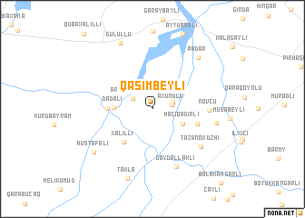
Qasımbeyli (Ağsu, Azerbaijan)Qasımbeyli is a town in the Ağsu region of Azerbaijan. An overview map of the region around Qasımbeyli is displayed below.
regional and 3d topo map of Qasımbeyli, Azerbaijan ::
Qasımbeyli airports ::
The nearest airport is BAK - Baku Heydar Aliyev, located 156.7 km east of Qasımbeyli.
Nearby towns ::
Axundlu (1.9km east) //
Ərǝbsarvan (2.1km north east) //
Ərǝbmehdibǝy (2.2km north west) //
Hacıqǝdirli (3.4km south east) //
Dǝdǝli (3.6km west) //
Xǝlilli (4.9km south west) //
Zǝrdab (4.2km west) //
Chiyni (4.6km south east) //
Növcü (5.3km east) //
Tazanovdzhi (6.5km south east) //
Göydǝllǝkli (7.4km south) //
Qaravǝlili (6.2km east) //
Padar (7.6km north east) //
Mustafalı (7.6km south west) //
Gülüllü (8.6km north) //
Tǝklǝ (8.9km south) //
[all distances 'as the bird flies' and approximate]  Places with similar names to Qasımbeyli, Azerbaijan ::
// Kasymly (AZ)
// Kazımlı (AZ)
// Qasimbǝyli (AZ)
// Qasımbǝyli (AZ)
// Qasımbǝyli (AZ)
// Qasımlı (AZ)
// Qasımlı (AZ)
// Keys Mill (US)
// Gosaumühle (AT)
// Casmalia (US)
Disclaimer :: Information on this page comes without warranty of any kind |
||
|
Where is Qasımbeyli? Elevation and coordinates ::
Latitude (lat): 40°32'0"N Longitude (lon): 48°12'0"E
Elevation (approx.): 66m (map arrows pan, magnifying glasses zoom) |
||
|
Visiting Qasımbeyli? Hotel/Accommodation ::
Book a hotel in Qasımbeyli Travel Guide ::
Buy a travel guide for Azerbaijan rental cars ::
car rental offers GPS waypoint ::
download a GPX waypoint (PoI) of Qasımbeyli for your GPS receiver
|
||