|
search place name
|
||
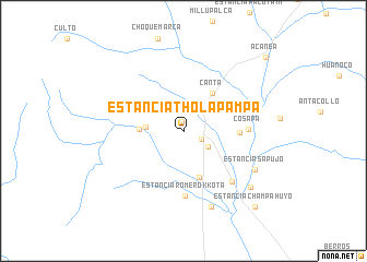
Estancia Thola Pampa (Oruro, Bolivia)Estancia Thola Pampa is a town in the Oruro region of Bolivia. An overview map of the region around Estancia Thola Pampa is displayed below.
regional and 3d topo map of Estancia Thola Pampa, Bolivia ::
Estancia Thola Pampa airports ::
The nearest airport is TCQ - Tacna Coronel Carlos Ciriani Santa Rosa Intl, located 164.7 km west of Estancia Thola Pampa.
Other airports nearby include ARI - Arica Chacalluta (171.5 km west), LPB - La Paz El Alto Intl (193.5 km north), Nearby towns ::
Estancia Wichu Kkollu (1.0km north) //
Estancia Iru Llallagua (1.9km south east) //
Estancia Khala Kkollu (2.9km south east) //
Estancia Uma Muyta (3.7km west) //
Changamoco (4.3km west) //
Canta (4.7km north east) //
Estancia Kkotaña (5.0km south) //
Estancia Jiltata Kkollu (5.5km east) //
Cosapa (6.3km east) //
Estancia Romero Kkota (6.6km south) //
Estancia Pasto Grande (7.0km south east) //
Estancia Caylla Choro (8.2km south) //
Estancia Sapujo (8.0km south east) //
Estancia Vila Kkola (8.7km south east) //
Estancia Champa Huyo (10.4km south east) //
Acanea (11.0km north east) //
[all distances 'as the bird flies' and approximate]  Places with similar names to Estancia Thola Pampa, Bolivia :: Disclaimer :: Information on this page comes without warranty of any kind |
||
|
Where is Estancia Thola Pampa? Elevation and coordinates ::
Latitude (lat): 18°11'4"S Longitude (lon): 68°43'34"W
Elevation (approx.): 3922m (map arrows pan, magnifying glasses zoom) |
||
|
Visiting Estancia Thola Pampa? Hotel/Accommodation ::
Book a hotel in Estancia Thola Pampa Travel Guide ::
Buy a travel guide for Bolivia rental cars ::
car rental offers GPS waypoint ::
download a GPX waypoint (PoI) of Estancia Thola Pampa for your GPS receiver
|
||