|
search place name
|
||
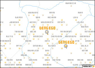
Dengego (Ethiopia)Dengego is a town in Ethiopia. An overview map of the region around Dengego is displayed below.
regional and 3d topo map of Dengego, Ethiopia ::
Dengego airports ::
The nearest airport is ADD - Addis Ababa Bole Intl, located 111.9 km south of Dengego.
Other airports nearby include BJR - Bahar Dar Bahir Dar (225.2 km north west), Nearby towns ::
Gebezī (0.0km north) //
Gende Jalo (1.8km east) //
Mene Ona (1.8km east) //
Menjaro (1.9km south) //
Kʼala Kʼendītī (1.8km west) //
Kembolcha (2.6km south east) //
Kotīcha (2.6km north east) //
Koto (3.7km south) //
Ējērē (3.7km south) //
Wedēsa Moto (3.7km north) //
Daletī (4.1km south east) //
Gubīya (4.1km north east) //
Chʼefē Kʼora (4.1km south east) //
Gīdabo (4.1km north west) //
Giranchʼa (4.1km south west) //
Kʼorē Yamo (5.2km south east) //
Kobī (5.5km east) //
Weldē (5.5km west) //
Ālkeso (5.9km south) //
Mechara (5.9km north) //
Chʼefē (5.9km south) //
Kīro (5.8km west) //
Ālantē (5.8km west) //
Yaya (6.6km south east) //
Rīfēntī (6.6km north east) //
Ījeta (6.6km north east) //
Wezemī (6.6km north west) //
Kʼerē Loya (6.6km north west) //
Ginde Belī (6.7km south west) //
[all distances 'as the bird flies' and approximate]  Places with similar names to Dengego, Ethiopia ::
Disclaimer :: Information on this page comes without warranty of any kind |
||
|
Where is Dengego? Elevation and coordinates ::
Latitude (lat): 9°57'0"N Longitude (lon): 38°31'0"E
Elevation (approx.): 2235m (map arrows pan, magnifying glasses zoom) |
||
|
Visiting Dengego? Hotel/Accommodation ::
Book a hotel in Dengego Travel Guide ::
Buy a travel guide for Ethiopia rental cars ::
car rental offers GPS waypoint ::
download a GPX waypoint (PoI) of Dengego for your GPS receiver
|
||