|
search place name
|
||
Wejo (Ethiopia)Wejo is a town in Ethiopia. An overview map of the region around Wejo is displayed below.
regional and 3d topo map of Wejo, Ethiopia ::

Wejo airports ::
The nearest airport is ADD - Addis Ababa Bole Intl, located 80.1 km south of Wejo.
Other airports nearby include BJR - Bahar Dar Bahir Dar (262.6 km north west), Nearby towns ::
Waju (0.0km north) //
Gura (0.0km north) //
Kʼorē Ēdī (0.0km north) //
Merechʼē (1.9km south) //
Tʼēnebo (1.9km north) //
Kʼecha (1.8km east) //
Muke Guracha (1.8km east) //
Āgajē (1.8km east) //
Ābīlamī (2.6km south west) //
Dīdo (2.6km north west) //
Wenjī (2.6km north east) //
Nachīrē (2.6km south east) //
Gulubī (2.6km south west) //
Jijiga (3.7km south) //
Butʼulī (3.7km south) //
Tembero (3.7km north) //
Debelītī (3.7km east) //
Deke Bora (3.7km west) //
Dirē Bochʼorē (4.1km north east) //
Īyeta (4.1km north east) //
Gishē (4.1km north west) //
Īta (4.1km south west) //
Giraro (4.1km north east) //
Girar (4.1km south west) //
Guragē (5.2km south east) //
Weld Āmī (5.2km north east) //
Bosē (5.6km north) //
Doyu (5.6km north) //
Felasē (5.6km north) //
[all distances 'as the bird flies' and approximate] 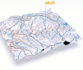 Places with similar names to Wejo, Ethiopia ::
Disclaimer :: Information on this page comes without warranty of any kind |
||
|
Where is Wejo? Elevation and coordinates ::
Latitude (lat): 9°42'0"N Longitude (lon): 38°45'0"E
Elevation (approx.): 2635m (map arrows pan, magnifying glasses zoom) |
||
|
Visiting Wejo? Hotel/Accommodation ::
Book a hotel in Wejo Travel Guide ::
Buy a travel guide for Ethiopia rental cars ::
car rental offers GPS waypoint ::
download a GPX waypoint (PoI) of Wejo for your GPS receiver
|
||