|
search place name
|
||
Phumĭ Khsê Dêk (Svay Riĕng, Cambodia)Phumĭ Khsê Dêk is a town in the Svay Riĕng region of Cambodia. An overview map of the region around Phumĭ Khsê Dêk is displayed below.
regional and 3d topo map of Phumĭ Khsê Dêk, Cambodia ::

Phumĭ Khsê Dêk airports ::
The nearest airport is PNH - Phnom-penh Phnom Penh Intl, located 111.8 km west of Phumĭ Khsê Dêk.
Other airports nearby include SGN - Ho Chi Minh City Tansonnhat Intl (113.0 km south east), Nearby towns ::
Xóm Giữa (1.8km east) //
Phumĭ Trás (1.9km north) //
Phumĭ Tasék (2.6km south east) //
Phumĭ Mreăk Tép (3.6km west) //
Phumĭ Kôkir (4.1km south east) //
Phumĭ Srê Rœssei (4.1km south west) //
Phumĭ Traôk (5.8km west) //
Lò Gò (5.8km north) //
Phumĭ Ângkrông (6.6km south west) //
Xóm Rẩy (6.6km north east) //
Phumĭ Tasuŏs (6.6km north west) //
Phumĭ Bœ̆ng Tasuŏs (6.6km north west) //
Chà Ruốt (7.3km east) //
Nàng Rà (7.5km east) //
Phumĭ Trâpeăng Pôpél (7.5km west) //
Phumĭ Sĕri Ŏs (7.5km west) //
Phumĭ Tbêng (7.8km south west) //
Phumĭ Trâpeăng Prei (7.8km south west) //
Xóm Bà Ðiết (8.2km north east) //
Phumĭ Kâmpóng Trach (10.4km south west) //
[all distances 'as the bird flies' and approximate] 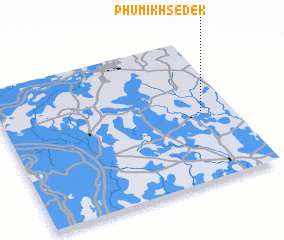 Places with similar names to Phumĭ Khsê Dêk, Cambodia :: Disclaimer :: Information on this page comes without warranty of any kind |
||
|
Where is Phumĭ Khsê Dêk? Elevation and coordinates ::
Latitude (lat): 11°29'0"N Longitude (lon): 105°52'0"E
Elevation (approx.): 16m (map arrows pan, magnifying glasses zoom) |
||
|
Visiting Phumĭ Khsê Dêk? Hotel/Accommodation ::
Book a hotel in Phumĭ Khsê Dêk Travel Guide ::
Buy a travel guide for Cambodia rental cars ::
car rental offers GPS waypoint ::
download a GPX waypoint (PoI) of Phumĭ Khsê Dêk for your GPS receiver
|
||