|
search place name
|
||
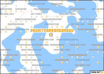
Phumĭ Trâpeăng A Moŭk (Prey Vêng, Cambodia)Phumĭ Trâpeăng A Moŭk is a town in the Prey Vêng region of Cambodia. An overview map of the region around Phumĭ Trâpeăng A Moŭk is displayed below.
regional and 3d topo map of Phumĭ Trâpeăng A Moŭk, Cambodia ::
Phumĭ Trâpeăng A Moŭk airports ::
The nearest airport is PNH - Phnom-penh Phnom Penh Intl, located 73.5 km west of Phumĭ Trâpeăng A Moŭk.
Other airports nearby include SGN - Ho Chi Minh City Tansonnhat Intl (145.1 km south east), REP - Siem-reap Siem Reap (281.0 km north west), Nearby towns ::
Phumĭ Trâpeăng Snaôr (0.0km north) //
Phumĭ Prey Chreăng (1) (1.8km east) //
Phumĭ Mœn Puŏk (2.6km north east) //
Phumĭ Ménóng (1) (2.6km north east) //
Phumĭ Srâlŏng (1) (2.6km north west) //
Phumĭ Prey Vôr (2.6km south west) //
Phumĭ Svay Kŭn (3.7km north) //
Phumĭ Trâpeăng Pring (3.6km west) //
Phumĭ Rumpeăk (4.1km south east) //
Phumĭ Sophi (4.1km north east) //
Phumĭ Prey Char (5.2km north east) //
Phumĭ Péanroŭng (5.2km south east) //
Phumĭ Bĕt Méas (5.2km south west) //
Phumĭ Koŭk Rôviĕng (1) (5.6km north) //
Phumĭ Dâmnăk Chasăng (5.8km east) //
Phumĭ Tuŏl Ta Pŏu (6.6km south east) //
Phumĭ Kbal Khvĕt (1) (6.6km south east) //
Phumĭ Chrey (7.6km north) //
Phumĭ Bœ̆ng Vêng (7.5km west) //
Phumĭ Svay At (7.6km north) //
Phumĭ Bœ̆ng Kák (8.3km north east) //
Phumĭ Kbal Khvĕt (2) (8.3km south east) //
Phumĭ Ângkôr Trét (8.2km north west) //
Phumĭ Bântéay Srê (8.2km south west) //
Phumĭ Don Yu (8.3km north west) //
Phumĭ Chrés (8.3km north west) //
Phumĭ Prey Tamók (9.2km north east) //
Phumĭ Prey Rœssei (9.2km north west) //
Vôtt Trach (9.2km north west) //
[all distances 'as the bird flies' and approximate]  Places with similar names to Phumĭ Trâpeăng A Moŭk, Cambodia :: Disclaimer :: Information on this page comes without warranty of any kind |
||
|
Where is Phumĭ Trâpeăng A Moŭk? Elevation and coordinates ::
Latitude (lat): 11°30'0"N Longitude (lon): 105°31'0"E
Elevation (approx.): 12m (map arrows pan, magnifying glasses zoom) |
||
|
Visiting Phumĭ Trâpeăng A Moŭk? Hotel/Accommodation ::
Book a hotel in Phumĭ Trâpeăng A Moŭk Travel Guide ::
Buy a travel guide for Cambodia rental cars ::
car rental offers GPS waypoint ::
download a GPX waypoint (PoI) of Phumĭ Trâpeăng A Moŭk for your GPS receiver
|
||