|
search place name
|
||
Bollenar (Región Metropolitana, Chile)Bollenar is a town in the Región Metropolitana region of Chile. An overview map of the region around Bollenar is displayed below.
regional and 3d topo map of Bollenar, Chile ::

Bollenar airports ::
The nearest airport is SCL - Santiago Arturo Merino Benitez Intl, located 63.6 km north west of Bollenar.
Other airports nearby include MDZ - Mendoza El Plumerillo (172.0 km north east), AFA - San Rafael (194.4 km south east), LGS - Malargue (201.8 km south), Nearby towns ::
El Ingenio (1.5km west) //
San Gabriel (2.4km south east) //
San Alfonso (5.9km north west) //
Queltehues (7.2km south east) //
[all distances 'as the bird flies' and approximate] 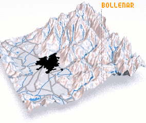 Places with similar names to Bollenar, Chile ::
// Balneario (ES)
// Belanera (MG)
// Bel-Nor (US)
// Bouliniéri (BJ)
// Baliniar (BF)
// Baleiniéré (TD)
// Balnāra (PK)
// Belenero (VE)
// Ballynure (JM)
// Blénoro (ML)
Disclaimer :: Information on this page comes without warranty of any kind |
||
|
Where is Bollenar? Elevation and coordinates ::
Latitude (lat): 33°46'0"S Longitude (lon): 70°16'0"W
Elevation (approx.): 1352m (map arrows pan, magnifying glasses zoom) |
||
|
Visiting Bollenar? Hotel/Accommodation ::
Book a hotel in Bollenar Travel Guide ::
Buy a travel guide for Chile rental cars ::
car rental offers GPS waypoint ::
download a GPX waypoint (PoI) of Bollenar for your GPS receiver
|
||