|
search place name
|
||
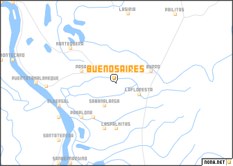
Buenos Aires (Sucre, Colombia)Buenos Aires is a town in the Sucre region of Colombia. An overview map of the region around Buenos Aires is displayed below.
regional and 3d topo map of Buenos Aires, Colombia ::
Buenos Aires airports ::
The nearest airport is OCV - Ocana Aguas Claras, located 72.6 km south east of Buenos Aires.
Other airports nearby include MGN - Magangue Baracoa (132.5 km west), CUC - Cucuta Camilo Daza (168.5 km south east), LFR - La Fria (173.6 km south east), CZU - Corozal Las Brujas (180.0 km west), Nearby towns ::
García (1.9km north) //
Palestina (2.6km north east) //
Pasacorriendo (4.1km north west) //
Sabana Larga (4.1km south west) //
La Floresta (4.1km south east) //
Coloradito (5.8km west) //
El Burro (5.8km east) //
Las Palmas (6.7km south west) //
Las Palmitas (7.4km south) //
El Tigre (7.6km south) //
Pamplona (7.8km south west) //
Mantequera (9.2km north west) //
[all distances 'as the bird flies' and approximate]  Places with similar names to Buenos Aires, Colombia ::
// Buenos Aires (PH)
// Buenos Aires (PH)
// Buenos Aires (PH)
// Buenos Aires (PH)
// Buenos Aires (PH)
// Buenos-Aires (PH)
// Buenos Aires (US)
// Buenos Aires (PA)
// Buenos Aires (PA)
// Buenos Aires (PA)
Disclaimer :: Information on this page comes without warranty of any kind |
||
|
Where is Buenos Aires? Elevation and coordinates ::
Latitude (lat): 8°52'0"N Longitude (lon): 73°43'0"W
Elevation (approx.): 41m (map arrows pan, magnifying glasses zoom) |
||
|
Visiting Buenos Aires? Hotel/Accommodation ::
Book a hotel in Buenos Aires Travel Guide ::
Buy a travel guide for Colombia rental cars ::
car rental offers GPS waypoint ::
download a GPX waypoint (PoI) of Buenos Aires for your GPS receiver
|
||