|
search place name
|
||
Lagunitas (Huila, Colombia)Lagunitas is a town in the Huila region of Colombia. An overview map of the region around Lagunitas is displayed below.
regional and 3d topo map of Lagunitas, Colombia ::

Lagunitas airports ::
The nearest airport is FLA - Florencia Gustavo Artunduaga Paredes, located 61.9 km south east of Lagunitas.
Other airports nearby include PPN - Popayan Guillermo Leon Valencia (97.7 km north west), NVA - Neiva Benito Salas (110.8 km north east), SVI - San Vincente De Caguan Eduardo Falla Solano (116.1 km east), CLO - Cali Alfonso Bonilla Aragon Intl (172.7 km north), Nearby towns ::
Serrezuela (0.6km south) //
La Trinidad (1.5km north) //
La Alejandría (1.8km south west) //
Moriela (2.3km east) //
Belén (2.5km north) //
Tarqui (2.6km north west) //
La Ardila (2.7km north) //
Corralón (2.9km west) //
El Corralón (3.0km west) //
Corinto (3.3km south east) //
El Totumo (3.4km north west) //
Zanjón del Totumo (3.5km north west) //
Higuillo (3.6km west) //
El Espinal (3.6km south west) //
Ucrania (3.7km west) //
Barrancas (4.0km north east) //
Altamira (4.0km south east) //
San Nicolás (4.0km north west) //
La Cañada (4.5km south west) //
Las Mercedes (4.7km north west) //
Campero (4.7km south east) //
Pelasal (4.8km north east) //
La Cañada (5.4km south west) //
El Carmen (5.5km north west) //
El Diamante (5.7km east) //
Topochera (6.4km north) //
La Cabaña (6.5km north west) //
La Muralla (6.6km north west) //
Pericongo (6.6km south west) //
[all distances 'as the bird flies' and approximate] 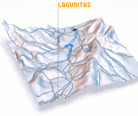 Places with similar names to Lagunitas, Colombia ::
// Lignitz (AT)
// Lagunitas (US)
// Lagnitz (DE)
// Löcknitz (DE)
// Löcknitz (DE)
// Löcknitz (DE)
// Lagunitas (PA)
// La Condesa (CU)
// Loknitsa (UA)
// La Condesa (ES)
Disclaimer :: Information on this page comes without warranty of any kind |
||
|
Where is Lagunitas? Elevation and coordinates ::
Latitude (lat): 2°5'32"N Longitude (lon): 75°48'29"W
Elevation (approx.): 991m (map arrows pan, magnifying glasses zoom) |
||
|
Visiting Lagunitas? Hotel/Accommodation ::
Book a hotel in Lagunitas Travel Guide ::
Buy a travel guide for Colombia rental cars ::
car rental offers GPS waypoint ::
download a GPX waypoint (PoI) of Lagunitas for your GPS receiver
|
||