|
search place name
|
||
La Mata (Cesar, Colombia)La Mata is a town in the Cesar region of Colombia. An overview map of the region around La Mata is displayed below.
regional and 3d topo map of La Mata, Colombia ::

La Mata airports ::
The nearest airport is OCV - Ocana Aguas Claras, located 101.6 km south east of La Mata.
Other airports nearby include MGN - Magangue Baracoa (121.7 km west), VUP - Valledupar Alfonso Lopez Pumarejo (152.4 km north), CZU - Corozal Las Brujas (170.3 km west), LFR - La Fria (191.1 km south east), Nearby towns ::
Nueva Ola (1.4km south west) //
El Amparo (1.9km north east) //
San José (3.4km east) //
Las Medias (4.3km south) //
Ultimo Caso (4.8km south) //
Las Flores (4.8km south east) //
Saloa (5.2km north east) //
Sindicate (5.5km south west) //
Notepases (5.6km south) //
Cabeceras (6.3km south east) //
Costa Rica (6.7km south) //
Mata de Guillín (7.1km south east) //
Las Mercedes (7.3km south east) //
El Mango (7.3km south east) //
Sapatí (7.5km south) //
Pozo de Barro (9.2km north west) //
Pozo de Barba (10.8km north west) //
[all distances 'as the bird flies' and approximate] 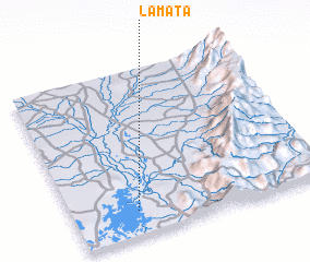 Places with similar names to La Mata, Colombia ::
Disclaimer :: Information on this page comes without warranty of any kind |
||
|
Where is La Mata? Elevation and coordinates ::
Latitude (lat): 9°8'54"N Longitude (lon): 73°44'50"W
Elevation (approx.): 34m (map arrows pan, magnifying glasses zoom) |
||
|
Visiting La Mata? Hotel/Accommodation ::
Book a hotel in La Mata Travel Guide ::
Buy a travel guide for Colombia rental cars ::
car rental offers GPS waypoint ::
download a GPX waypoint (PoI) of La Mata for your GPS receiver
|
||