|
search place name
|
||
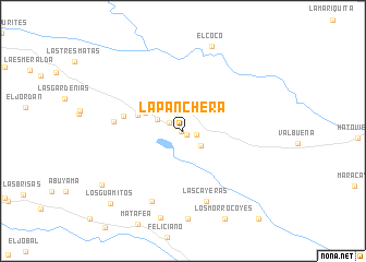
La Panchera (Departamento de Arauca, Colombia)La Panchera is a town in the Departamento de Arauca region of Colombia. An overview map of the region around La Panchera is displayed below.
regional and 3d topo map of La Panchera, Colombia ::
La Panchera airports ::
The nearest airport is AUC - Arauca Santiago Perez, located 33.0 km north west of La Panchera.
Other airports nearby include TME - Tame (152.0 km west), STD - Santo Domingo Mayor Buenaventura Vivas (186.4 km west), BNS - Barinas (188.8 km north), MRD - Merida Alberto Carnevalli (197.8 km north), Nearby towns ::
La Porfía (0.2km south west) //
Pelero (0.5km south east) //
La Veracruz (0.8km north west) //
La Maporata (1.4km east) //
El Cerrito (1.6km north west) //
Moscu (2.4km south east) //
Yopo (2.5km north west) //
El Milagro (2.9km north west) //
La Estación (4.3km north west) //
La Vigía (4.9km west) //
El Charal (6.2km west) //
Campoalegre (7.1km west) //
Las Cayeras (7.6km south) //
El Velorio (7.8km south west) //
El Coco (9.1km north) //
El Guayabo (9.2km south) //
El Candidero (10.0km south west) //
Los Guamitos (10.4km south west) //
[all distances 'as the bird flies' and approximate]  Places with similar names to La Panchera, Colombia ::
// La Panchera (VE)
Disclaimer :: Information on this page comes without warranty of any kind |
||
|
Where is La Panchera? Elevation and coordinates ::
Latitude (lat): 6°55'52"N Longitude (lon): 70°28'18"W
Elevation (approx.): 120m (map arrows pan, magnifying glasses zoom) |
||
|
Visiting La Panchera? Hotel/Accommodation ::
Book a hotel in La Panchera Travel Guide ::
Buy a travel guide for Colombia rental cars ::
car rental offers GPS waypoint ::
download a GPX waypoint (PoI) of La Panchera for your GPS receiver
|
||