|
search place name
|
||
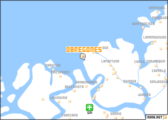
Obregones (Cauca, Colombia)Obregones is a town in the Cauca region of Colombia. An overview map of the region around Obregones is displayed below.
regional and 3d topo map of Obregones, Colombia ::
Obregones airports ::
The nearest airport is GPI - Guapi Juan Casiano, located 10.7 km south of Obregones.
Other airports nearby include TCO - Tumaco La Florida (132.6 km south west), PPN - Popayan Guillermo Leon Valencia (146.6 km east), PSO - Pasto Antonio Narino (156.4 km south east), BUN - Buenaventura Gerardo Tobar Lopez (163.5 km north east), Nearby towns ::
Playita de Quiroga (2.7km north east) //
San Bernardo (5.9km south) //
La Fortuna (6.0km east) //
Chico Pérez (6.4km south west) //
Cantil (6.7km south east) //
Pejesapo (6.8km east) //
Concepción (6.8km south east) //
San Antonio (6.9km south east) //
Vaquitas (7.2km west) //
Estero Hondo (7.2km south east) //
Bellavista (7.2km south) //
Chamón (7.4km south east) //
Iguanero (7.5km east) //
Chimbilaquero (8.4km south) //
La Esperanza (8.4km south east) //
Canta Delicias (8.9km south) //
[all distances 'as the bird flies' and approximate]  Places with similar names to Obregones, Colombia ::
Disclaimer :: Information on this page comes without warranty of any kind |
||
|
Where is Obregones? Elevation and coordinates ::
Latitude (lat): 2°39'59"N Longitude (lon): 77°54'38"W
Elevation (approx.): 21m (map arrows pan, magnifying glasses zoom) |
||
|
Visiting Obregones? Hotel/Accommodation ::
Book a hotel in Obregones Travel Guide ::
Buy a travel guide for Colombia rental cars ::
car rental offers GPS waypoint ::
download a GPX waypoint (PoI) of Obregones for your GPS receiver
|
||