|
search place name
|
||
Pastales (Tolima, Colombia)Pastales is a town in the Tolima region of Colombia. An overview map of the region around Pastales is displayed below.
regional and 3d topo map of Pastales, Colombia ::

Pastales airports ::
The nearest airport is IBE - Ibague Perales, located 21.3 km south east of Pastales.
Other airports nearby include AXM - Armenia El Eden (52.2 km west), PEI - Pereira Matecana (58.7 km north west), MZL - Manizales La Nubia (59.6 km north), ULQ - Tulua Farfan (114.1 km south west), Nearby towns ::
Villa Restrepo (2.6km north west) //
El Cajón (7.3km south west) //
Chapetón (7.6km south east) //
El Moral (8.3km south east) //
El Palmar (9.3km north west) //
Meridiano (9.2km north east) //
Tapias (9.4km south west) //
Ibagué (11.5km south east) //
[all distances 'as the bird flies' and approximate] 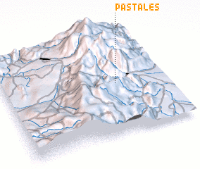 Places with similar names to Pastales, Colombia ::
// Peustelsau (DE)
// Postolice (PL)
// Pozo Dulce (CU)
// Pištelići (BA)
// Posadillas (ES)
// Pozo de Luis (MX)
// Pozo Dulce (VE)
// Puesto Lucy (PY)
// Puesto Luis (PY)
// Počedělice (CZ)
Disclaimer :: Information on this page comes without warranty of any kind |
||
|
Where is Pastales? Elevation and coordinates ::
Latitude (lat): 4°31'0"N Longitude (lon): 75°18'0"W
Elevation (approx.): 1851m (map arrows pan, magnifying glasses zoom) |
||
|
Visiting Pastales? Hotel/Accommodation ::
Book a hotel in Pastales Travel Guide ::
Buy a travel guide for Colombia rental cars ::
car rental offers GPS waypoint ::
download a GPX waypoint (PoI) of Pastales for your GPS receiver
|
||