|
search place name
|
||
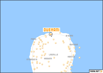
Ouémani (Grande Comore, Comoros)Ouémani is a town in the Grande Comore region of Comoros. An overview map of the region around Ouémani is displayed below.
regional and 3d topo map of Ouémani, Comoros ::
Ouémani airports ::
The nearest airport is HAH - Moroni Prince Said Ibrahim, located 17.9 km south of Ouémani.
Other airports nearby include NWA - Moheli Bandaressalam (112.3 km south east), AJN - Anjouan Ouani (146.3 km south east), DZA - Dzaoudzi Pamandzi (264.9 km south east), Nearby towns ::
Ouéla (1.3km south east) //
Memboua Bouani (2.0km west) //
Trou du Prophète (2.2km west) //
Membouadjou (2.6km south west) //
Koua (2.8km south east) //
Bangoua Kouni (3.3km north east) //
Toyifa (3.5km south west) //
Bangouamafsakoa (3.9km south west) //
Pidjani (4.0km south west) //
Songomani (4.0km west) //
Nkourani (4.2km west) //
Balsa (4.4km east) //
Mitsamiouli (4.5km west) //
Anihani (4.7km south west) //
Ntsadjéni (4.9km south west) //
Ouzio (4.9km south east) //
Mandza (5.3km south west) //
Founga (5.4km south west) //
Ouhozi (5.4km south west) //
Douniani (6.0km south west) //
Zouda (6.3km south west) //
Helendjé (6.6km south) //
Fâssi (6.6km west) //
Ivouani (6.7km east) //
Koua (7.0km south west) //
Ndzaouze (7.0km south west) //
Mrouadjou (7.1km south east) //
Minoungouni (7.3km south) //
Bandamadji (7.5km south east) //
[all distances 'as the bird flies' and approximate] 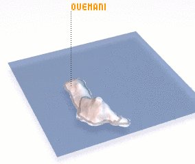 Places with similar names to Ouémani, Comoros ::
Disclaimer :: Information on this page comes without warranty of any kind |
||
|
Where is Ouémani? Elevation and coordinates ::
Latitude (lat): 11°22'49"S Longitude (lon): 43°19'31"E
Elevation (approx.): 29m (map arrows pan, magnifying glasses zoom) |
||
|
Visiting Ouémani? Hotel/Accommodation ::
Book a hotel in Ouémani Travel Guide ::
Buy a travel guide for Comoros rental cars ::
car rental offers GPS waypoint ::
download a GPX waypoint (PoI) of Ouémani for your GPS receiver
|
||