|
search place name
|
||
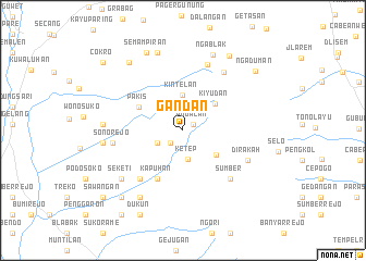
Gandan (Jawa Tengah, Indonesia)Gandan is a town in the Jawa Tengah region of Indonesia. An overview map of the region around Gandan is displayed below.
regional and 3d topo map of Gandan, Indonesia ::
Nearby towns ::
Pogalan (1.2km north east) //
Belang Dua (1.8km south west) //
Banyumari (2.9km south west) //
Ketep (3.0km south) //
Kintelan (3.6km north) //
Windusabrang (4.2km south east) //
Kiyudan (4.3km north east) //
Pakis (5.1km north west) //
Kapuhan (5.6km south west) //
Jati (6.6km south west) //
Sumber (6.9km south east) //
Lodosawu (7.1km north) //
Jogonayan (7.3km north east) //
Sonorejo (7.3km west) //
Dirakah (7.3km south east) //
Seketi (8.0km south west) //
Krogowanan (8.1km south west) //
Pasekan (8.1km west) //
Kasihan (8.2km west) //
Ngablak (8.4km north) //
Selomirah (8.4km north) //
Semampiran (8.8km north west) //
Ketawang (8.9km north west) //
Kopeng (9.0km north east) //
Banyutemumpang (9.3km south west) //
Ngaduman (9.5km north east) //
Dukun (9.7km south west) //
Sawangan (10.6km south west) //
Cokro (10.7km north west) //
[all distances 'as the bird flies' and approximate]  Places with similar names to Gandan, Indonesia ::
Disclaimer :: Information on this page comes without warranty of any kind |
||
|
Where is Gandan? Elevation and coordinates ::
Latitude (lat): 7°28'19"S Longitude (lon): 110°22'24"E
Elevation (approx.): 1172m (map arrows pan, magnifying glasses zoom) |
||
|
Visiting Gandan? Hotel/Accommodation ::
Book a hotel in Gandan Travel Guide ::
Buy a travel guide for Indonesia rental cars ::
car rental offers GPS waypoint ::
download a GPX waypoint (PoI) of Gandan for your GPS receiver
|
||