|
search place name
|
||
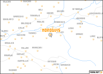
Morodvis (Macedonia, The Republic of)Morodvis is a town in Macedonia, The Republic of. An overview map of the region around Morodvis is displayed below.
regional and 3d topo map of Morodvis, Macedonia, The Republic of ::
Morodvis airports ::
The nearest airport is SKP - Skopje, located 67.1 km west of Morodvis.
Other airports nearby include SOF - Sofia (124.6 km north east), PRN - Pristina (139.4 km north west), SKG - Thessaloniki Makedonia (154.8 km south), OHD - Ohrid (158.2 km south west), Nearby towns ::
Vidovište (1.4km west) //
Zrnovci (2.5km east) //
Grdovci (3.6km north) //
Mojanci (4.0km north west) //
Pribačevo (4.8km north east) //
Podlog (5.2km north west) //
Teranci (5.1km west) //
Pripečani (6.3km south west) //
Kočani (7.5km north) //
Leski (5.8km east) //
Trakanje (7.9km north west) //
Orizari (8.6km north) //
Beli (9.2km north) //
Junuzlija (9.8km south west) //
[all distances 'as the bird flies' and approximate]  Places with similar names to Morodvis, Macedonia, The Republic of ::
// Mrtvice (BA)
// Muratovići (BA)
// Muratovići (BA)
// Muratovići (BA)
// Muratovići (BA)
// Mordves (RU)
// Martovce (SK)
// Miradovići (CS)
// Muratovići (CS)
Disclaimer :: Information on this page comes without warranty of any kind |
||
|
Where is Morodvis? Elevation and coordinates ::
Latitude (lat): 41°50'56"N Longitude (lon): 22°24'55"E
Elevation (approx.): 422m (map arrows pan, magnifying glasses zoom) |
||
|
Visiting Morodvis? Hotel/Accommodation ::
Book a hotel in Morodvis Travel Guide ::
rental cars ::
car rental offers GPS waypoint ::
download a GPX waypoint (PoI) of Morodvis for your GPS receiver
|
||