|
search place name
|
||
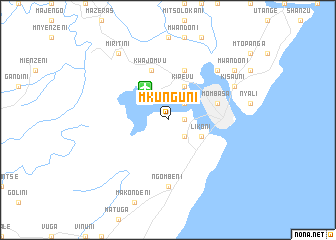
Mkunguni (Coast, Kenya)Mkunguni is a town in the Coast region of Kenya. An overview map of the region around Mkunguni is displayed below.
regional and 3d topo map of Mkunguni, Kenya ::
Mkunguni airports ::
The nearest airport is MBA - Mombasa Moi Intl, located 4.3 km north west of Mkunguni.
Other airports nearby include TGT - Tanga (128.6 km south west), PMA - Pemba (133.4 km south), LAU - Lamu Manda (247.0 km north east), Nearby towns ::
Mtongwe (1.8km east) //
Kindunguni (2.6km south east) //
Shimanzi (2.6km north east) //
Likoni (4.1km south east) //
Kipevu (4.1km north east) //
Changamwe (5.9km north) //
Old Mombasa (5.8km east) //
Mombasa (5.8km east) //
Kwa Jomvu (5.9km north) //
Ngombeni (7.4km south) //
Junda (7.9km north east) //
Kisauni (8.3km north east) //
Mwandoni (9.3km north east) //
Miritini (9.3km north west) //
[all distances 'as the bird flies' and approximate]  Places with similar names to Mkunguni, Kenya ::
// Maconacon (PH)
// Magungunay (PH)
// Makongani (KE)
// Mkongani (KE)
// Mukunguni (KE)
// Makangonio (GA)
// Mukangani (ZM)
// Makongoni (TZ)
// Mgongoni (TZ)
// Mikunguni (TZ)
Disclaimer :: Information on this page comes without warranty of any kind |
||
|
Where is Mkunguni? Elevation and coordinates ::
Latitude (lat): 4°4'0"S Longitude (lon): 39°37'0"E
Elevation (approx.): 13m (map arrows pan, magnifying glasses zoom) |
||
|
Visiting Mkunguni? Hotel/Accommodation ::
Book a hotel in Mkunguni Travel Guide ::
Buy a travel guide for Kenya rental cars ::
car rental offers GPS waypoint ::
download a GPX waypoint (PoI) of Mkunguni for your GPS receiver
|
||