|
search place name
|
||
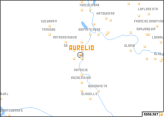
Aurelio (Veracruz-Llave, Mexico)Aurelio is a town in the Veracruz-Llave region of Mexico. An overview map of the region around Aurelio is displayed below.
regional and 3d topo map of Aurelio, Mexico ::
Aurelio airports ::
The nearest airport is MTT - Minatitlan, located 78.9 km north west of Aurelio.
Other airports nearby include VSA - Villahermosa C P A Carlos Rovirosa Intl (126.2 km east), TGZ - Tuxtla Gutierrez Angel Albino Corzo (160.9 km south east), Nearby towns ::
Laja San Pedro (0.0km north) //
San Pedro Mexcapala (1.8km west) //
Pascual (1.9km north) //
San Pedrito (2.6km north west) //
Patricio (3.7km south) //
Loma Alegría (3.7km north) //
Potrero Nuevo (5.1km north west) //
Poza Crispín (5.6km south) //
Cipriano (5.8km north) //
Santa Teresa (5.8km north) //
Esperanza (6.6km north east) //
Arroyo Grande (7.4km south) //
Buenavista (7.7km north east) //
Buenavista (8.2km south east) //
El Fronterizo (8.3km north) //
El Relajo (8.3km north east) //
Trinidad (9.0km north west) //
Xucuapan (10.2km north west) //
Francisco Villa (10.8km north east) //
[all distances 'as the bird flies' and approximate] 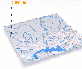 Places with similar names to Aurelio, Mexico ::
Disclaimer :: Information on this page comes without warranty of any kind |
||
|
Where is Aurelio? Elevation and coordinates ::
Latitude (lat): 17°42'0"N Longitude (lon): 93°58'0"W
Elevation (approx.): 14m (map arrows pan, magnifying glasses zoom) |
||
|
Visiting Aurelio? Hotel/Accommodation ::
Book a hotel in Aurelio Travel Guide ::
Buy a travel guide for Mexico rental cars ::
car rental offers GPS waypoint ::
download a GPX waypoint (PoI) of Aurelio for your GPS receiver
|
||