|
search place name
|
||
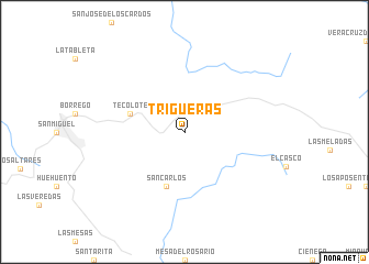
Trigueras (Durango, Mexico)Trigueras is a town in the Durango region of Mexico. An overview map of the region around Trigueras is displayed below.
regional and 3d topo map of Trigueras, Mexico ::
Trigueras airports ::
The nearest airport is DGO - Durango Intl, located 126.6 km east of Trigueras.
Other airports nearby include MZT - Mazatlan General Rafael Buelna Intl (149.3 km south), CUL - Culiacan Intl (180.5 km west), Nearby towns ::
Tecolote (5.4km west) //
San Carlos (5.8km south) //
[all distances 'as the bird flies' and approximate]  Places with similar names to Trigueras, Mexico ::
// Dar Kraïz (MA)
// Truckers (US)
// Torregrosa (ES)
// Trigueros (ES)
// Darreh Korsī (IR)
// Deer Cross (US)
// Turrúcares (CR)
// Terre Grasse (HT)
// Trou Gras (HT)
// Trégourez (FR)
Disclaimer :: Information on this page comes without warranty of any kind |
||
|
Where is Trigueras? Elevation and coordinates ::
Latitude (lat): 24°25'0"N Longitude (lon): 105°44'0"W
Elevation (approx.): 2517m (map arrows pan, magnifying glasses zoom) |
||
|
Visiting Trigueras? Hotel/Accommodation ::
Book a hotel in Trigueras Travel Guide ::
Buy a travel guide for Mexico rental cars ::
car rental offers GPS waypoint ::
download a GPX waypoint (PoI) of Trigueras for your GPS receiver
|
||