|
search place name
|
||
Umm al Birak (Al Madīnah, Saudi Arabia)Umm al Birak is a town in the Al Madīnah region of Saudi Arabia. An overview map of the region around Umm al Birak is displayed below.
regional and 3d topo map of Umm al Birak, Saudi Arabia ::

Umm al Birak airports ::
The nearest airport is MED - Madinah Prince Mohammad Bin Abdulaziz, located 133.7 km north of Umm al Birak.
Other airports nearby include YNB - Yenbo (143.0 km north west), JED - Jeddah King Abdulaziz Intl (193.8 km south), TIF - Taif (254.3 km south east), Nearby towns ::
[all distances 'as the bird flies' and approximate] 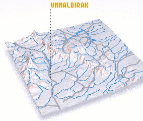 Places with similar names to Umm al Birak, Saudi Arabia ::
Disclaimer :: Information on this page comes without warranty of any kind |
||
|
Where is Umm al Birak? Elevation and coordinates ::
Latitude (lat): 23°25'41"N Longitude (lon): 39°13'49"E
Elevation (approx.): 187m (map arrows pan, magnifying glasses zoom) |
||
|
Visiting Umm al Birak? Hotel/Accommodation ::
Book a hotel in Umm al Birak Travel Guide ::
rental cars ::
car rental offers GPS waypoint ::
download a GPX waypoint (PoI) of Umm al Birak for your GPS receiver
|
||