|
search place name
|
||
Kampong Kepala Kerbau (Kedah, Malaysia)Kampong Kepala Kerbau is a town in the Kedah region of Malaysia. An overview map of the region around Kampong Kepala Kerbau is displayed below.
regional and 3d topo map of Kampong Kepala Kerbau, Malaysia ::

Kampong Kepala Kerbau airports ::
The nearest airport is AOR - Alor Setar Sultan Abdul Halim, located 25.1 km south of Kampong Kepala Kerbau.
Other airports nearby include HDY - Songkhla Hat Yai Intl (57.1 km north), LGK - Pulau Langkawi Intl (74.9 km west), PAN - Pattani (92.8 km north east), PEN - Penang Intl (124.6 km south), Nearby towns ::
Kampong Sungai Buloh (0.0km north) //
Kampong Sira (1.8km east) //
Kampong Jenalik (1.8km east) //
Kampong Baharu Che Harun (1.8km west) //
Kampong Palas (2.6km north east) //
Kampong Titi Ara (2.6km north east) //
Kampong Bedang Baharu (2.6km north east) //
Kampong Padang (2.6km north east) //
Kampong Masjid (3.7km east) //
Kampong Padang Halban (3.7km east) //
Kampong Belukar (3.7km east) //
Kampong Titi Kerbau (3.7km north) //
Kampong Padang Keriang (3.7km north) //
Kampong Kubu (3.7km north) //
Kampong Kubang Eriang (3.7km north) //
Kampong Tokong (4.1km north east) //
Canglun (4.1km north east) //
Kampong Nong Mee (4.1km north east) //
Kampong Bendang Tok Leh (4.1km north east) //
Kampong Masjid (4.1km north east) //
Kampong Padang Labi (4.1km north east) //
Kampong Bendang Perang (4.1km south east) //
Kampong Langsat (4.1km north west) //
Kampong Sungai Atun (4.1km north west) //
Kampong Tanjong Putus (5.2km north east) //
Kampong Kubang Pasu (5.2km south east) //
Kampong Cherok Makan (5.6km south) //
Kampong Changhai (5.8km east) //
Kampong Rawa (5.8km east) //
[all distances 'as the bird flies' and approximate] 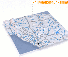 Places with similar names to Kampong Kepala Kerbau, Malaysia :: Disclaimer :: Information on this page comes without warranty of any kind |
||
|
Where is Kampong Kepala Kerbau? Elevation and coordinates ::
Latitude (lat): 6°25'0"N Longitude (lon): 100°24'0"E
Elevation (approx.): 40m (map arrows pan, magnifying glasses zoom) |
||
|
Visiting Kampong Kepala Kerbau? Hotel/Accommodation ::
Book a hotel in Kampong Kepala Kerbau Travel Guide ::
Buy a travel guide for Malaysia rental cars ::
car rental offers GPS waypoint ::
download a GPX waypoint (PoI) of Kampong Kepala Kerbau for your GPS receiver
|
||