|
search place name
|
||
Kampong Masjid (Perak, Malaysia)Kampong Masjid is a town in the Perak region of Malaysia. An overview map of the region around Kampong Masjid is displayed below.
regional and 3d topo map of Kampong Masjid, Malaysia ::

Kampong Masjid airports ::
The nearest airport is IPH - Ipoh Sultan Azlan Shah, located 22.9 km south east of Kampong Masjid.
Other airports nearby include PEN - Penang Intl (98.3 km north west), AOR - Alor Setar Sultan Abdul Halim (175.1 km north), NAW - Narathiwat (220.4 km north east), KBR - Kota Bahru Sultan Ismail Petra (221.4 km north east), Nearby towns ::
Kampong Changkat Lalang (0.0km north) //
Kampong Sementa (1.9km south) //
Kampong Kuala Kenas (1.9km south) //
Kampong Telangdengah (1.8km east) //
Kampong Kubang Pekan (1.8km east) //
Kampong Ulu Kenas (2.6km south west) //
Kampong Kuala Menora (2.6km north east) //
Kampong Paya Kelabor (2.6km north east) //
Kampong Senggang (3.7km south) //
Kampong Langkap (3.7km north) //
Kampung Pulau (4.1km north west) //
Kampong Ketior (4.1km north west) //
Kampong Tanah Lepan (4.1km north east) //
Kampong Rambai Tujoh (4.1km south east) //
Kampong Sungai Sireh (4.1km south east) //
Jerlun (5.2km north west) //
Kampong Java (5.6km north) //
Kampong Pachat (5.9km south) //
Kampong Jerlun (5.9km north) //
Kampong Sungai Akar (5.8km east) //
Kampong Kelebor (5.8km west) //
Kampong Senawar (5.9km north) //
Kampong Sungai Siput (5.9km north) //
Lempur (6.7km south west) //
Kampong Chermin (6.7km north east) //
Kampong Padang Changkat (6.7km north east) //
Kuala Kangsar (7.4km north) //
Kampong Bukit Damar (7.6km south) //
Kampong Talang Masjid (7.6km north) //
[all distances 'as the bird flies' and approximate] 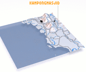 Places with similar names to Kampong Masjid, Malaysia ::
// Kampong Masjid (MY)
// Kampong Masjid (MY)
// Kampong Masjid (MY)
// Kampong Masjid (MY)
// Kampong Masjid (MY)
// Kampong Masjid (MY)
// Kampong Masjid (MY)
// Kampong Masjid (MY)
// Kampong Masjid (MY)
// Kampong Masjid (MY)
Disclaimer :: Information on this page comes without warranty of any kind |
||
|
Where is Kampong Masjid? Elevation and coordinates ::
Latitude (lat): 4°42'0"N Longitude (lon): 100°56'0"E
Elevation (approx.): 75m (map arrows pan, magnifying glasses zoom) |
||
|
Visiting Kampong Masjid? Hotel/Accommodation ::
Book a hotel in Kampong Masjid Travel Guide ::
Buy a travel guide for Malaysia rental cars ::
car rental offers GPS waypoint ::
download a GPX waypoint (PoI) of Kampong Masjid for your GPS receiver
|
||