|
search place name
|
||
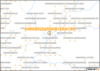
Kampong Sungai Ayer Hitam (Kedah, Malaysia)Kampong Sungai Ayer Hitam is a town in the Kedah region of Malaysia. An overview map of the region around Kampong Sungai Ayer Hitam is displayed below.
regional and 3d topo map of Kampong Sungai Ayer Hitam, Malaysia ::
Kampong Sungai Ayer Hitam airports ::
The nearest airport is PEN - Penang Intl, located 45.6 km west of Kampong Sungai Ayer Hitam.
Other airports nearby include IPH - Ipoh Sultan Azlan Shah (86.4 km south east), AOR - Alor Setar Sultan Abdul Halim (110.4 km north), LGK - Pulau Langkawi Intl (160.9 km north west), PAN - Pattani (179.4 km north), Nearby towns ::
Kampong Medan (0.0km north) //
Kampong Kuala Selama (0.0km north) //
Kampong Gudang (1.9km south) //
Kampong Banggol Rashid (1.9km south) //
Kampong Paya Deras (1.9km north) //
Kampong Kuala Dingin (1.9km north) //
Kampong Gua Petai (1.8km east) //
Kampong Menteri Road (2.6km south east) //
Selama (2.6km south east) //
Kampong Seribu Relong (2.6km north west) //
Changkat Jenehing (2.6km north east) //
Kampong Sungai Semut (3.7km south) //
Kampong Terap (3.7km south) //
Kampong Sungai Tengas (3.7km north) //
Kampong Gua Bergambar (4.1km south west) //
Kampong Limau (4.1km south west) //
Kampong Batu Tiga (4.1km north east) //
Kampong Medan (4.1km north east) //
Kampong Batu Lintang (5.2km south west) //
Kampong Bagan Jermai (5.2km north east) //
Rantau Panjang (5.5km east) //
Kampong Tengah (5.5km east) //
Kampong Tengas Masjid (5.6km north) //
Kampong Sungai Buloh (5.6km north) //
Kampong Sungai Jambu (5.6km south) //
Kampong Pechah Batu (5.8km west) //
Kampong Sungai Salleh (5.8km west) //
Kampong Mesjid (5.8km east) //
Kampong Banggol Durian (6.7km north east) //
[all distances 'as the bird flies' and approximate]  Places with similar names to Kampong Sungai Ayer Hitam, Malaysia ::
// Kampong Sungai Ayer Hitam (MY)
Disclaimer :: Information on this page comes without warranty of any kind |
||
|
Where is Kampong Sungai Ayer Hitam? Elevation and coordinates ::
Latitude (lat): 5°14'0"N Longitude (lon): 100°41'0"E
Elevation (approx.): 32m (map arrows pan, magnifying glasses zoom) |
||
|
Visiting Kampong Sungai Ayer Hitam? Hotel/Accommodation ::
Book a hotel in Kampong Sungai Ayer Hitam Travel Guide ::
Buy a travel guide for Malaysia rental cars ::
car rental offers GPS waypoint ::
download a GPX waypoint (PoI) of Kampong Sungai Ayer Hitam for your GPS receiver
|
||