|
search place name
|
||
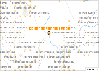
Kampong Sungai Terap (Kedah, Malaysia)Kampong Sungai Terap is a town in the Kedah region of Malaysia. An overview map of the region around Kampong Sungai Terap is displayed below.
regional and 3d topo map of Kampong Sungai Terap, Malaysia ::
Kampong Sungai Terap airports ::
The nearest airport is PEN - Penang Intl, located 39.5 km west of Kampong Sungai Terap.
Other airports nearby include IPH - Ipoh Sultan Azlan Shah (94.1 km south east), AOR - Alor Setar Sultan Abdul Halim (103.6 km north), LGK - Pulau Langkawi Intl (153.1 km north west), PAN - Pattani (175.8 km north), Nearby towns ::
Kampong Bendang Sara (0.0km north) //
Bukit Gajah Lawan (1.9km north) //
Kampong Sungai Malau (2.6km south west) //
Kampong Durian Burong (4.1km south west) //
Kepun Kopi (5.2km south west) //
Kampong Seribu Relong (5.2km south east) //
Kampong Tengas Masjid (5.5km east) //
Kampong Sungai Buloh (5.5km east) //
Kampong Sungai Tengas (5.8km east) //
Kampong Kuala Dingin (6.7km south east) //
Kampong Paya Deras (6.7km south east) //
Kampong Sungai Punti (6.7km south west) //
Kampong Pechah Batu (7.4km south) //
Kampong Sungai Salleh (7.4km south) //
Kampong Tengah (7.6km south) //
Serdang (7.6km south) //
Kampong Ayer Hitam (7.6km south) //
Kampong Kasal (7.6km east) //
Kampong Kuala Selama (7.8km south east) //
Kampong Sungai Ayer Hitam (7.8km south east) //
Kampong Medan (7.8km south east) //
Kampong Setul (8.3km south west) //
Kampong Leret (8.3km south west) //
Changkat Jenehing (8.3km south east) //
Kampong Batu Ampac (8.3km north west) //
Kampong Sungai Batu (8.3km north east) //
Kampong Gudang (9.3km south east) //
Kampong Banggol Rashid (9.3km south east) //
Kampong Padang (9.2km south west) //
[all distances 'as the bird flies' and approximate]  Places with similar names to Kampong Sungai Terap, Malaysia ::
// Kampong Sungai Terap (MY)
Disclaimer :: Information on this page comes without warranty of any kind |
||
|
Where is Kampong Sungai Terap? Elevation and coordinates ::
Latitude (lat): 5°17'0"N Longitude (lon): 100°38'0"E
Elevation (approx.): 61m (map arrows pan, magnifying glasses zoom) |
||
|
Visiting Kampong Sungai Terap? Hotel/Accommodation ::
Book a hotel in Kampong Sungai Terap Travel Guide ::
Buy a travel guide for Malaysia rental cars ::
car rental offers GPS waypoint ::
download a GPX waypoint (PoI) of Kampong Sungai Terap for your GPS receiver
|
||