|
search place name
|
||
Simpang Lima (Perak, Malaysia)Simpang Lima is a town in the Perak region of Malaysia. An overview map of the region around Simpang Lima is displayed below.
regional and 3d topo map of Simpang Lima, Malaysia ::

Simpang Lima airports ::
The nearest airport is PEN - Penang Intl, located 32.9 km north west of Simpang Lima.
Other airports nearby include IPH - Ipoh Sultan Azlan Shah (88.4 km south east), AOR - Alor Setar Sultan Abdul Halim (122.7 km north), LGK - Pulau Langkawi Intl (161.2 km north west), PAN - Pattani (202.3 km north), Nearby towns ::
Kampong Tanah Kebun (1.8km west) //
Kampong Jalan Baharu (2.6km south west) //
Simpang Tiga (3.7km north) //
Titi Serong (4.1km north west) //
Kampong Kedah (4.1km north west) //
Parit Buntar (4.1km north east) //
Kampong Sa Lengkun (5.2km south west) //
Kampong Sungai Bogak (5.2km south east) //
Kampong Asam Kumbang (5.2km north east) //
Kampong Tengah (5.2km north east) //
Kampong Permatang To' Mahat (5.6km north) //
Permatang Keling (5.9km north) //
Kampong Sungai Setar (5.9km north) //
Kampong Parit To'Ngah (5.8km west) //
Bandar Baharu (5.9km north) //
Simpang Tiga (6.7km south west) //
Kampong Sungai Siakap (6.7km south west) //
Parit Nibong (6.7km north east) //
Kampong Pasir Hantu (6.7km north east) //
Kampong Sungai Tepus (6.7km north east) //
Kampong Permatang Pasir (6.7km north east) //
Kampong Bagan Samak (6.7km north east) //
Kampong Tepuso (6.7km north east) //
Kampong Raja (7.4km east) //
Kampong Tanjong Nipis (7.6km south) //
Kampong Matang Gerdu (7.6km south) //
Tanjong Berembang (7.6km north) //
Rantau Panjang (7.6km north) //
Parit Tok Mandin (7.6km north) //
[all distances 'as the bird flies' and approximate] 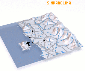 Places with similar names to Simpang Lima, Malaysia ::
// Simpang Lima (MY)
// Simpangolim (ID)
Disclaimer :: Information on this page comes without warranty of any kind |
||
|
Where is Simpang Lima? Elevation and coordinates ::
Latitude (lat): 5°5'0"N Longitude (lon): 100°29'0"E
Elevation (approx.): 5m (map arrows pan, magnifying glasses zoom) |
||
|
Visiting Simpang Lima? Hotel/Accommodation ::
Book a hotel in Simpang Lima Travel Guide ::
Buy a travel guide for Malaysia rental cars ::
car rental offers GPS waypoint ::
download a GPX waypoint (PoI) of Simpang Lima for your GPS receiver
|
||