|
search place name
|
||
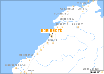
María Soto (Colón, Panama)María Soto is a town in the Colón region of Panama. An overview map of the region around María Soto is displayed below.
regional and 3d topo map of María Soto, Panama ::
María Soto airports ::
The nearest airport is PTY - Panama City Tocumen Intl, located 59.3 km south east of María Soto.
Other airports nearby include PAC - Panama Marcos A Gelabert Intl (61.7 km south), HOW - Howard (67.2 km south), Nearby towns ::
Can Can (0.0km north) //
Iguanita (2.2km south) //
Buenaventura (2.6km north east) //
Guanche (2.6km south west) //
Marco Antonio (2.7km south west) //
La Escucha (4.1km north east) //
Tiende Ropa (4.8km south west) //
Portobelo (5.2km north east) //
Punta Gorda (6.1km south west) //
Santa Isabel (7.8km north east) //
Santa Elena (7.8km north east) //
Río Piedra (8.0km south west) //
Boca de la Quebrada (8.3km north east) //
Juan Chiquito (8.3km north east) //
Playa Blanca (8.3km north east) //
María Chiquita (11.4km south west) //
[all distances 'as the bird flies' and approximate]  Places with similar names to María Soto, Panama ::
Disclaimer :: Information on this page comes without warranty of any kind |
||
|
Where is María Soto? Elevation and coordinates ::
Latitude (lat): 9°31'0"N Longitude (lon): 79°41'0"W
Elevation (approx.): 65m (map arrows pan, magnifying glasses zoom) |
||
|
Visiting María Soto? Hotel/Accommodation ::
Book a hotel in María Soto Travel Guide ::
Buy a travel guide for Panama rental cars ::
car rental offers GPS waypoint ::
download a GPX waypoint (PoI) of María Soto for your GPS receiver
|
||