|
search place name
|
||
‘Abd Allāh al ‘Awwād (Al Anbār, Iraq)‘Abd Allāh al ‘Awwād is a town in the Al Anbār region of Iraq. An overview map of the region around ‘Abd Allāh al ‘Awwād is displayed below.
regional and 3d topo map of ‘Abd Allāh al ‘Awwād, Iraq ::
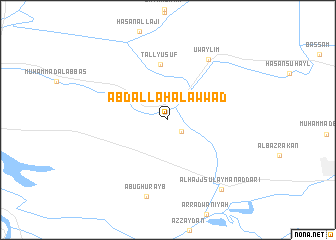
Nearby towns ::
ShaykhDir‘ al Muḩammad (1.8km south east) //
Tall Yūsuf (6.2km north) //
‘Uwaylim (7.8km north east) //
Abū Ghurayb (8.7km south) //
Al Ḩājj Sulaymān aḑ Ḑārī (9.2km south east) //
[all distances 'as the bird flies' and approximate]  Places with similar names to ‘Abd Allāh al ‘Awwād, Iraq :: Disclaimer :: Information on this page comes without warranty of any kind |
||
|
Where is ‘Abd Allāh al ‘Awwād? Elevation and coordinates ::
Latitude (lat): 33°21'40"N Longitude (lon): 44°0'42"E
Elevation (approx.): 37m (map arrows pan, magnifying glasses zoom) |
||
|
Visiting ‘Abd Allāh al ‘Awwād? Hotel/Accommodation ::
Book a hotel in ‘Abd Allāh al ‘Awwād Travel Guide ::
Buy a travel guide for Iraq rental cars ::
car rental offers GPS waypoint ::
download a GPX waypoint (PoI) of ‘Abd Allāh al ‘Awwād for your GPS receiver
|
||