|
search place name
|
||
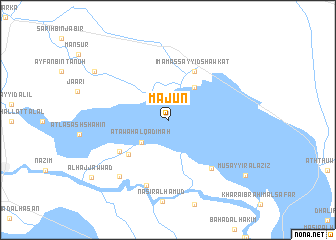
Mājūn (Al Muthanná, Iraq)Mājūn is a town in the Al Muthanná region of Iraq. An overview map of the region around Mājūn is displayed below.
regional and 3d topo map of Mājūn, Iraq ::
Mājūn airports ::
The nearest airport is RAH - Rafha, located 270.0 km south west of Mājūn.
Nearby towns ::
Ra‘d al Barghash (2.6km north) //
‘Aţāwah al Qadīmah (3.6km south west) //
Qal‘at Ḩusayn al Ḩamādī (4.4km north east) //
Imām Nāşir (5.4km south west) //
Sabtī (5.4km south west) //
Imām as Sayyid Shawkat (6.0km north east) //
Akwām Nāşir (5.8km south west) //
Al Ḩāfiz̧ (6.8km south east) //
Al Khunaynīyah (7.6km south) //
As Suwayr (7.8km south west) //
Mawtān (8.8km north west) //
Musayyir al ‘Azīz (9.7km south east) //
Al Ḩājj ‘Awwād (9.8km south west) //
[all distances 'as the bird flies' and approximate]  Places with similar names to Mājūn, Iraq ::
Disclaimer :: Information on this page comes without warranty of any kind |
||
|
Where is Mājūn? Elevation and coordinates ::
Latitude (lat): 31°22'4"N Longitude (lon): 45°27'24"E
Elevation (approx.): 11m (map arrows pan, magnifying glasses zoom) |
||
|
Visiting Mājūn? Hotel/Accommodation ::
Book a hotel in Mājūn Travel Guide ::
Buy a travel guide for Iraq rental cars ::
car rental offers GPS waypoint ::
download a GPX waypoint (PoI) of Mājūn for your GPS receiver
|
||