|
search place name
|
||
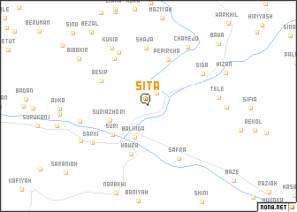
Sītā (Dahūk, Iraq)Sītā is a town in the Dahūk region of Iraq. An overview map of the region around Sītā is displayed below.
regional and 3d topo map of Sītā, Iraq ::
Sītā airports ::
The nearest airport is VAN - Van, located 164.3 km north of Sītā.
Nearby towns ::
Pir-ā Mārik (1.8km north east) //
Bālinda (4.2km south) //
Sūrī-ā Zhōrī (4.3km south west) //
Sūrī (5.1km south west) //
Pēpirkha (6.1km north) //
Hawra (6.3km south) //
Bēsip (5.7km north west) //
Duhok (6.9km north west) //
Shājā (7.4km north) //
Safra (7.3km south east) //
Sārkī (7.4km north west) //
Sīdā (6.9km north east) //
Sārkī (7.3km south west) //
Kūkir (8.2km north west) //
Shīlādiza (7.2km west) //
Tēlē (7.1km east) //
Chamējū (8.4km north east) //
Khastō (8.1km south west) //
Bībakir (9.2km north west) //
Bāwa (10.6km north east) //
[all distances 'as the bird flies' and approximate]  Places with similar names to Sītā, Iraq ::
Disclaimer :: Information on this page comes without warranty of any kind |
||
|
Where is Sītā? Elevation and coordinates ::
Latitude (lat): 37°3'2"N Longitude (lon): 43°52'9"E
Elevation (approx.): 839m (map arrows pan, magnifying glasses zoom) |
||
|
Visiting Sītā? Hotel/Accommodation ::
Book a hotel in Sītā Travel Guide ::
Buy a travel guide for Iraq rental cars ::
car rental offers GPS waypoint ::
download a GPX waypoint (PoI) of Sītā for your GPS receiver
|
||