|
search place name
|
||
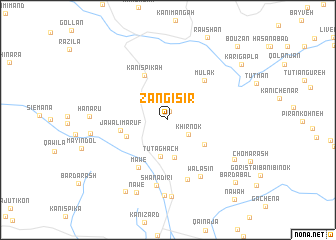
Zangisir (As Sulaymānīyah, Iraq)Zangisir is a town in the As Sulaymānīyah region of Iraq. An overview map of the region around Zangisir is displayed below.
regional and 3d topo map of Zangisir, Iraq ::
Zangisir airports ::
The nearest airport is SDG - Sanandaj, located 104.8 km east of Zangisir.
Other airports nearby include KSH - Bakhtaran Shahid Ashrafi Esfahani (171.7 km south east), Nearby towns ::
Kolitan (1.0km north) //
Khirnōk (2.4km south east) //
Tūt Aghāch (4.1km south) //
Bargurgan (4.3km south) //
Balbaris (4.3km south east) //
Kaolos (4.2km south west) //
Jawāl-i Ma'rūf (4.5km west) //
Kānī Spīkah (5.4km north west) //
Mūlāk (5.5km north east) //
Māwē (5.9km south west) //
Ush Qubbah (6.9km south) //
Walasin (7.0km south east) //
Shānādirī (7.4km south) //
Shānadarī Khwārū (8.4km south) //
Qarah Yatākh (8.5km south) //
Bōrīdar (7.5km south east) //
Hanarū (7.1km west) //
Hōz-i Hawāja (7.2km west) //
Nawē (8.6km south) //
Kachālī (8.8km south west) //
Bardabal (9.3km south east) //
Karigapla (9.2km north east) //
Bouzan (10.3km north east) //
[all distances 'as the bird flies' and approximate]  Places with similar names to Zangisir, Iraq ::
// Sangesra (IN)
// Sangeh Sar (IR)
Disclaimer :: Information on this page comes without warranty of any kind |
||
|
Where is Zangisir? Elevation and coordinates ::
Latitude (lat): 35°29'36"N Longitude (lon): 45°53'48"E
Elevation (approx.): 889m (map arrows pan, magnifying glasses zoom) |
||
|
Visiting Zangisir? Hotel/Accommodation ::
Book a hotel in Zangisir Travel Guide ::
Buy a travel guide for Iraq rental cars ::
car rental offers GPS waypoint ::
download a GPX waypoint (PoI) of Zangisir for your GPS receiver
|
||