|
search place name
|
||
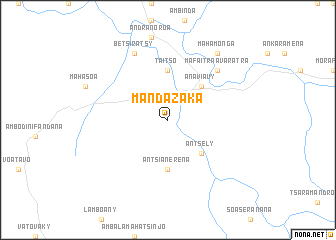
Mandazaka (Fianarantsoa, Madagascar)Mandazaka is a town in the Fianarantsoa region of Madagascar. An overview map of the region around Mandazaka is displayed below.
regional and 3d topo map of Mandazaka, Madagascar ::
Mandazaka airports ::
The nearest airport is WFI - Fianarantsoa, located 87.3 km north east of Mandazaka.
Other airports nearby include WVK - Manakara (155.9 km east), RVA - Farafangana (161.2 km south east), MNJ - Mananjary (210.2 km north east), Nearby towns ::
Anaviavy (5.1km north east) //
Antsely (5.1km south east) //
Taitso (5.6km north) //
Antsianerena (5.6km south) //
Mafaitra Avaratra (7.6km north east) //
Betsiratsy (8.2km north west) //
Mahamonga (9.0km north east) //
[all distances 'as the bird flies' and approximate]  Places with similar names to Mandazaka, Madagascar ::
// Mandasig (PH)
// Mantscha (AT)
// Muntscha (DE)
// Montasico (IT)
// Monte Seco (PT)
// Manotskiy (RU)
// Mondzoku (CD)
// Mandzoko (CG)
// Mindzoukou (CG)
// Montasik (ID)
Disclaimer :: Information on this page comes without warranty of any kind |
||
|
Where is Mandazaka? Elevation and coordinates ::
Latitude (lat): 22°0'0"S Longitude (lon): 46°31'0"E
Elevation (approx.): 778m (map arrows pan, magnifying glasses zoom) |
||
|
Visiting Mandazaka? Hotel/Accommodation ::
Book a hotel in Mandazaka Travel Guide ::
Buy a travel guide for Madagascar rental cars ::
car rental offers GPS waypoint ::
download a GPX waypoint (PoI) of Mandazaka for your GPS receiver
|
||