|
search place name
|
||
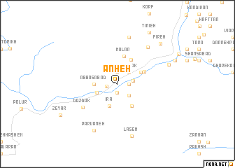
Ānheh (Māzandarān, Iran)Ānheh is a town in the Māzandarān region of Iran. An overview map of the region around Ānheh is displayed below.
regional and 3d topo map of Ānheh, Iran ::
Ānheh airports ::
The nearest airport is THR - Teheran Mehrabad Intl, located 81.5 km west of Ānheh.
Other airports nearby include RZR - Ramsar (176.6 km north west), Nearby towns ::
Nīāk (1.4km south) //
Rīneh (1.4km west) //
Hūn (1.9km north) //
Pol-e Mūn (1.5km east) //
Garnā (1.9km north) //
Gīlās (1.5km east) //
Rīneh (2.3km north) //
Kāndolū (2.1km east) //
Kenār Anjām (2.4km south east) //
Lazīrak (2.4km north east) //
Amīrābād (2.4km north east) //
Āb Ask (3.0km south west) //
‘Abbāsābād (3.0km west) //
Īrā (3.7km south) //
Garmābdar (3.5km north east) //
Nevā (4.0km south east) //
Gazāneh (4.2km north east) //
Malār (4.5km north) //
Gazanak (4.0km north east) //
Dozdak (5.8km south west) //
Āb Garm-e-Lārījān (7.1km north east) //
Esteleh Sar (7.6km north) //
Parvāneh (8.0km south) //
Lāsem (8.5km south) //
Shangoldeh (7.3km north east) //
Fīreh (8.5km north east) //
Tinīeh (9.2km north east) //
[all distances 'as the bird flies' and approximate]  Places with similar names to Ānheh, Iran ::
Disclaimer :: Information on this page comes without warranty of any kind |
||
|
Where is Ānheh? Elevation and coordinates ::
Latitude (lat): 35°53'0"N Longitude (lon): 52°11'0"E
Elevation (approx.): 1847m (map arrows pan, magnifying glasses zoom) |
||
|
Visiting Ānheh? Hotel/Accommodation ::
Book a hotel in Ānheh Travel Guide ::
Buy a travel guide for Iran rental cars ::
car rental offers GPS waypoint ::
download a GPX waypoint (PoI) of Ānheh for your GPS receiver
|
||