|
search place name
|
||
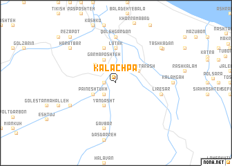
Kalāchpā (Iran)Kalāchpā is a town in Iran. An overview map of the region around Kalāchpā is displayed below.
regional and 3d topo map of Kalāchpā, Iran ::
Kalāchpā airports ::
The nearest airport is RZR - Ramsar, located 29.4 km north west of Kalāchpā.
Other airports nearby include THR - Teheran Mehrabad Intl (117.9 km south), RAS - Rasht (131.7 km north west), Nearby towns ::
Pordsar (1.5km west) //
Tūsā Kalām (2.4km south west) //
Dārbār (2.4km north west) //
Pā'īn Eshtūkh (3.5km south west) //
Qāshoqtarāsh (3.5km north east) //
Yāndasht (4.0km south) //
Garmā Poshteh (4.0km north) //
Kal Poshteh (3.9km north west) //
Latāk (5.6km north) //
Emām Zamīn (5.8km north) //
Qal‘eh Gardan (7.4km north) //
Līresar (6.2km east) //
Gāvbar (7.6km south) //
Bālā Eshtūkh (7.0km south west) //
Tashkadan (8.1km north east) //
Harātbar (8.1km north west) //
Sīāvarz (8.1km north east) //
Reẕā Poţ (9.5km north west) //
Balţān (9.5km north west) //
[all distances 'as the bird flies' and approximate] 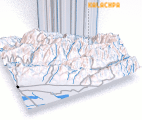 Places with similar names to Kalāchpā, Iran ::
// Galāchipa (BD)
// Kylyshpay (KZ)
// Collachapi (PE)
// Kilchu-ŭp (KP)
// Calchupa (BO)
// Callichapi (BO)
// Calochapa (AO)
Disclaimer :: Information on this page comes without warranty of any kind |
||
|
Where is Kalāchpā? Elevation and coordinates ::
Latitude (lat): 36°41'0"N Longitude (lon): 50°51'0"E
Elevation (approx.): 385m (map arrows pan, magnifying glasses zoom) |
||
|
Visiting Kalāchpā? Hotel/Accommodation ::
Book a hotel in Kalāchpā Travel Guide ::
Buy a travel guide for Iran rental cars ::
car rental offers GPS waypoint ::
download a GPX waypoint (PoI) of Kalāchpā for your GPS receiver
|
||