|
search place name
|
||
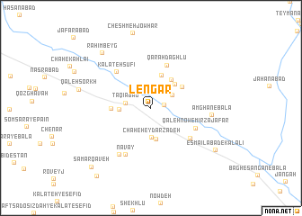
Lengar (Khorāsān, Iran)Lengar is a town in the Khorāsān region of Iran. An overview map of the region around Lengar is displayed below.
regional and 3d topo map of Lengar, Iran ::
Lengar airports ::
The nearest airport is HEA - Herat, located 209.5 km south east of Lengar.
Nearby towns ::
Maḩmūdābād-e Pāʼīn (1.4km east) //
Moḩammadābād-e Bālā (2.7km north east) //
Taqīābād (2.7km west) //
Chāh-e Ḩeydar Zādeh (3.6km south) //
Chāh-e Barzgar (3.9km south) //
Asadābād (3.3km west) //
Mowrī (3.8km north east) //
Kalāteh-ye Fāẕel (4.2km north) //
Jalīlābād (4.1km north east) //
Maḩmūdābād-e Bālā (4.1km north east) //
Khorramābād (4.0km west) //
Qarah Dāghlū (5.5km north) //
Qal‘eh Now-e Mīrzā Ja‘far (5.2km south east) //
Ḩājjīābād (5.4km south east) //
Kalāteh Şūfī (5.7km north west) //
Navāy (6.3km south west) //
Gandah Khālū (6.5km south west) //
Amghān-e Bālā (6.2km east) //
Raḩīmbeyg (8.5km north west) //
Esmā‘īlābād-e Kalālī (8.3km south east) //
Samar Qāveh (9.5km south west) //
Gol Varzeh (10.1km south west) //
[all distances 'as the bird flies' and approximate]  Places with similar names to Lengar, Iran ::
Disclaimer :: Information on this page comes without warranty of any kind |
||
|
Where is Lengar? Elevation and coordinates ::
Latitude (lat): 35°23'4"N Longitude (lon): 60°26'9"E
Elevation (approx.): 1017m (map arrows pan, magnifying glasses zoom) |
||
|
Visiting Lengar? Hotel/Accommodation ::
Book a hotel in Lengar Travel Guide ::
Buy a travel guide for Iran rental cars ::
car rental offers GPS waypoint ::
download a GPX waypoint (PoI) of Lengar for your GPS receiver
|
||