|
search place name
|
||
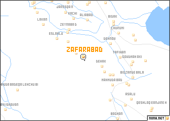
Z̧afarābād (Fārs, Iran)Z̧afarābād is a town in the Fārs region of Iran. An overview map of the region around Z̧afarābād is displayed below.
regional and 3d topo map of Z̧afarābād, Iran ::
Z̧afarābād airports ::
The nearest airport is SYZ - Shiraz Shahid Dastghaib Intl, located 14.1 km north of Z̧afarābād.
Other airports nearby include BUZ - Bushehr (177.8 km west), Nearby towns ::
Kūshk Bīdak (2.3km north west) //
Dehak (3.5km east) //
Dowlatābād (4.5km south east) //
Gāv Bāz (5.3km north west) //
Esmā‘īlābād (5.8km south east) //
Deh Now (6.2km north east) //
Kūshk-e Khalīl (6.3km south east) //
Sanjānak (7.0km north west) //
Zeynābād (7.6km north west) //
Tafīhān (6.8km east) //
Eslāmlū (7.3km north west) //
Maḩmūdābād (7.6km south east) //
Chūrūmī (8.9km north east) //
Pol-e Fasā (9.7km north east) //
Gardaneh-ye Bābā Ḩājjī (10.0km south east) //
Bīdak (10.3km north east) //
[all distances 'as the bird flies' and approximate] 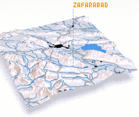 Places with similar names to Z̧afarābād, Iran ::
Disclaimer :: Information on this page comes without warranty of any kind |
||
|
Where is Z̧afarābād? Elevation and coordinates ::
Latitude (lat): 29°24'43"N Longitude (lon): 52°35'0"E
Elevation (approx.): 1484m (map arrows pan, magnifying glasses zoom) |
||
|
Visiting Z̧afarābād? Hotel/Accommodation ::
Book a hotel in Z̧afarābād Travel Guide ::
Buy a travel guide for Iran rental cars ::
car rental offers GPS waypoint ::
download a GPX waypoint (PoI) of Z̧afarābād for your GPS receiver
|
||