|
search place name
|
||
Tanga (Federally Administered Tribal Areas, Pakistan)Tanga is a town in the Federally Administered Tribal Areas region of Pakistan. An overview map of the region around Tanga is displayed below.
regional and 3d topo map of Tanga, Pakistan ::

Tanga airports ::
The nearest airport is PEW - Peshawar Intl, located 66.8 km south of Tanga.
Other airports nearby include JAA - Jalalabad (71.3 km west), SDT - Saidu Sharif (104.9 km east), ISB - Islamabad Chaklala (199.8 km south east), Nearby towns ::
Ganda Ghar (0.7km east) //
Gāgizai (0.9km north) //
Lakarai (1.2km north west) //
Sro Korūna (1.5km south) //
Adīn Khel (1.7km north) //
Biān Khel (1.7km south east) //
Ghāziābād (1.8km north west) //
Khādi Khel (2.4km south) //
Kharkanai (2.8km south) //
Taraki Tang (3.0km south) //
Bāgh (2.7km west) //
Khānkāh (2.9km north west) //
Ziārat (4.3km north) //
Garhi (4.6km south) //
Kalagai (4.3km north east) //
Shawai (4.7km north) //
Karkano Kili (5.0km south) //
Kund Kuhai (4.7km south east) //
Khatin (4.6km west) //
Māndurai (5.5km north) //
Spenalo Kili (5.6km south) //
Aman Kot (4.8km south west) //
Khazina Warsak (5.7km north) //
Yara Khel (5.0km west) //
Palosin (6.1km south) //
Dāg Qala (6.0km south east) //
Palosai (6.4km south) //
Akhkarzai Dāg (6.3km north) //
Khazīna (6.4km north) //
[all distances 'as the bird flies' and approximate] 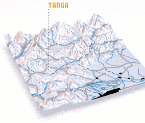 Places with similar names to Tanga, Pakistan ::
Disclaimer :: Information on this page comes without warranty of any kind |
||
|
Where is Tanga? Elevation and coordinates ::
Latitude (lat): 34°33'20"N Longitude (lon): 71°15'5"E
Elevation (approx.): 767m (map arrows pan, magnifying glasses zoom) |
||
|
Visiting Tanga? Hotel/Accommodation ::
Book a hotel in Tanga Travel Guide ::
Buy a travel guide for Pakistan rental cars ::
car rental offers GPS waypoint ::
download a GPX waypoint (PoI) of Tanga for your GPS receiver
|
||