|
search place name
|
||
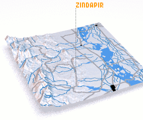
Zinda Pīr (Punjab, Pakistan)Zinda Pīr is a town in the Punjab region of Pakistan. An overview map of the region around Zinda Pīr is displayed below.
regional and 3d topo map of Zinda Pīr, Pakistan ::

Zinda Pīr airports ::
The nearest airport is MUX - Multan Intl, located 94.6 km east of Zinda Pīr.
Other airports nearby include PZH - Zhob (141.8 km north west), SUL - Sui (232.8 km south west), Nearby towns ::
 Places with similar names to Zinda Pīr, Pakistan ::
// Santa Pera (PA)
// Sant Pere (AD)
// Sāntapāra (BD)
// Sāntipur (BD)
// Saint-Pierre (CD)
// Saint Pierre (CG)
// Sāntipur (IN)
// Santpur (IN)
// Sāntpur (IN)
// Santpura (IN)
Disclaimer :: Information on this page comes without warranty of any kind |
||
|
Where is Zinda Pīr? Elevation and coordinates ::
Latitude (lat): 30°25'0"N Longitude (lon): 70°28'0"E
Elevation (approx.): 332m (map arrows pan, magnifying glasses zoom) |
||
|
Visiting Zinda Pīr? Hotel/Accommodation ::
Book a hotel in Zinda Pīr Travel Guide ::
Buy a travel guide for Pakistan rental cars ::
car rental offers GPS waypoint ::
download a GPX waypoint (PoI) of Zinda Pīr for your GPS receiver
|
||