|
search place name
|
||
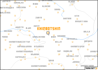
Khirbat Shīn (Jordan)Khirbat Shīn is a town in Jordan. An overview map of the region around Khirbat Shīn is displayed below.
regional and 3d topo map of Khirbat Shīn, Jordan ::
Khirbat Shīn airports ::
The nearest airport is OMF - Mafraq King Hussein, located 43.3 km east of Khirbat Shīn.
Other airports nearby include ADJ - Amman Marka Intl (49.0 km south), RPN - Rosh Pina Mahanaim I Ben Yaakov (69.7 km north), AMM - Amman Queen Alia Intl (75.5 km south), HFA - Haifa (85.3 km north west), Nearby towns ::
Khirbat ‘Afnā (1.6km east) //
Khirbat ‘Uşaym (1.9km north) //
‘Ibbīn (2.4km south east) //
Khirbat Sin‘ār (2.4km north west) //
Umm al Manābī‘ (3.6km south west) //
Rāsūn (4.5km north west) //
Şakhrah (4.5km east) //
‘Ibillīn (4.9km south east) //
Ishtafaynā (5.0km west) //
Khirbat aţ Ţayyārah (5.0km west) //
Khirbat Miḩnā (5.0km west) //
Riḩābā (6.2km north) //
‘Ayn Jannā (6.4km south west) //
Zūbiyā (6.4km north west) //
Bā‘ūn (6.3km west) //
‘Irjān (6.6km west) //
‘Ajlūn (7.2km south west) //
Khirbat Ra”s al Madīnah (8.0km south east) //
Sūf (8.0km south east) //
Shaţanā (8.0km north east) //
Şamad (9.1km north) //
‘Anjarah (9.5km south west) //
Muqbilah (9.7km south east) //
[all distances 'as the bird flies' and approximate]  Places with similar names to Khirbat Shīn, Jordan :: Disclaimer :: Information on this page comes without warranty of any kind |
||
|
Where is Khirbat Shīn? Elevation and coordinates ::
Latitude (lat): 32°23'0"N Longitude (lon): 35°48'0"E
Elevation (approx.): 1081m (map arrows pan, magnifying glasses zoom) |
||
|
Visiting Khirbat Shīn? Hotel/Accommodation ::
Book a hotel in Khirbat Shīn Travel Guide ::
Buy a travel guide for Jordan rental cars ::
car rental offers GPS waypoint ::
download a GPX waypoint (PoI) of Khirbat Shīn for your GPS receiver
|
||