|
search place name
|
||
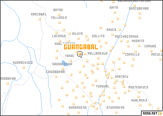
Guangabal (La Libertad, Peru)Guangabal is a town in the La Libertad region of Peru. An overview map of the region around Guangabal is displayed below.
regional and 3d topo map of Guangabal, Peru ::
Guangabal airports ::
The nearest airport is TRU - Trujillo Capitan Carlos Martinez De Pinillos, located 132.4 km west of Guangabal.
Other airports nearby include JJI - Juanjui (150.5 km north east), CHM - Chimbote Teniente Jaime A De Montreuil Morales (164.2 km south west), CHH - Chachapoyas (174.9 km north), ATA - Anta Comandante Fap German Arias Graziani (177.5 km south), Nearby towns ::
Hacienda Pampataque (1.3km north east) //
Patauli (1.4km south east) //
Jaboncillo (1.8km north west) //
Lorichuco (1.9km south) //
Yanac (2.6km west) //
La Colpa (3.1km south east) //
Huayahual (3.2km south) //
Vaquería (3.2km north west) //
Naupalli (3.7km south east) //
Pallar Bajo (3.8km east) //
Ugurchuco (3.9km east) //
Hacienda Purrupi (4.0km south) //
Hualtipampa (4.2km north west) //
Chiquichal (4.3km south east) //
Hacienda Yanasara (4.3km south east) //
Collasgón (4.5km south west) //
Chumaca (4.5km north) //
Miluya (4.6km north) //
Querobal (4.7km south) //
Hacienda Agocasa (4.9km north west) //
El Pallar (4.9km east) //
Sausacocha (5.0km south west) //
Chilico (5.1km north) //
Pallar Alto (5.2km north east) //
Gollito (5.6km north east) //
Santa Pampa (5.7km west) //
Hacienda Porvenir (5.7km south) //
Sanja Pampa (5.8km west) //
Candurco (6.1km south east) //
[all distances 'as the bird flies' and approximate]  Places with similar names to Guangabal, Peru ::
// Concabella (ES)
// Kinkubala (CD)
// Cancábal (GT)
// Cancábal (GT)
// Kancabal (MX)
// Kangabala (ZM)
// Koingbélo (GN)
// Kankböle (FI)
// Quenquibol (PH)
// Gongabli (LR)
Disclaimer :: Information on this page comes without warranty of any kind |
||
|
Where is Guangabal? Elevation and coordinates ::
Latitude (lat): 7°46'50"S Longitude (lon): 77°56'47"W
Elevation (approx.): 3022m (map arrows pan, magnifying glasses zoom) |
||
|
Visiting Guangabal? Hotel/Accommodation ::
Book a hotel in Guangabal Travel Guide ::
Buy a travel guide for Peru rental cars ::
car rental offers GPS waypoint ::
download a GPX waypoint (PoI) of Guangabal for your GPS receiver
|
||