|
search place name
|
||
Milca (Lima, Peru)Milca is a town in the Lima region of Peru. An overview map of the region around Milca is displayed below.
regional and 3d topo map of Milca, Peru ::

Milca airports ::
The nearest airport is LIM - Lima Jorge Chavez Intl, located 78.5 km west of Milca.
Other airports nearby include PIO - Pisco Intl (211.7 km south), Nearby towns ::
Collana (0.9km south) //
Macumpata (1.3km south) //
Niña Pampa (1.6km south) //
Matucana (2.1km south east) //
Huariquiña (2.2km south east) //
Monterrico (2.3km south east) //
San Pedro (2.6km south east) //
Los Olivos (3.1km east) //
Ayas (3.3km south west) //
Huaripampa (3.3km east) //
Paihua (3.4km north east) //
Anchimaja (3.7km south west) //
Sacrampe (4.0km south) //
Buena Vista (3.9km south east) //
Timapampa (4.1km east) //
Chuelocuya (4.2km east) //
San Juan de Allauca (4.5km north east) //
Pueblo Libre (5.0km south) //
Miramar (5.1km south west) //
Surco (5.4km south west) //
Huishcol (5.4km north east) //
Pinlla (5.6km south) //
Cacachaqui (5.5km east) //
Chilca (5.5km east) //
Malla (5.7km north east) //
Chacra Alta (5.8km south west) //
Puquiña (5.8km east) //
Jurco (5.9km south) //
Huangro (5.9km east) //
[all distances 'as the bird flies' and approximate] 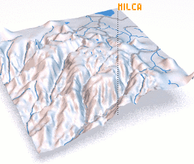 Places with similar names to Milca, Peru ::
Disclaimer :: Information on this page comes without warranty of any kind |
||
|
Where is Milca? Elevation and coordinates ::
Latitude (lat): 11°50'28"S Longitude (lon): 76°25'3"W
Elevation (approx.): 2764m (map arrows pan, magnifying glasses zoom) |
||
|
Visiting Milca? Hotel/Accommodation ::
Book a hotel in Milca Travel Guide ::
Buy a travel guide for Peru rental cars ::
car rental offers GPS waypoint ::
download a GPX waypoint (PoI) of Milca for your GPS receiver
|
||