|
search place name
|
||
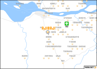
Ajibaji (Gongola, Nigeria)Ajibaji is a town in the Gongola region of Nigeria. An overview map of the region around Ajibaji is displayed below.
regional and 3d topo map of Ajibaji, Nigeria ::
Ajibaji airports ::
The nearest airport is MDI - Makurdi, located 8.2 km north east of Ajibaji.
Other airports nearby include ENU - Enugu (171.2 km south west), ABV - Abuja Nnamdi Azikiwe Intl (205.1 km north west), JOS - Jos Yakubu Gowon (221.0 km north), BPC - Bamenda (250.2 km south east), Nearby towns ::
Hembe (1.8km east) //
Amena (1.9km south) //
Yaiko (1.8km east) //
Kanshio (2.6km north west) //
Kyabashi (3.7km east) //
Tse Poor (3.7km east) //
Apir (3.7km south) //
Ugoh (3.7km south) //
Gbashima (3.7km south) //
Nyikua (4.1km north east) //
Sum Apir (4.1km south east) //
Stasungu (4.1km south east) //
Ageva (5.2km north east) //
Jabela (5.5km east) //
Bende (5.5km east) //
Ataata (5.5km east) //
Ada (5.8km east) //
Iyorember Aninov (5.9km south) //
Walmayo (7.4km north) //
Akume (7.3km east) //
Makurdi (7.6km north) //
Utenger (9.2km north east) //
Uga Soja (9.2km north east) //
Tse Aduku (10.4km south east) //
[all distances 'as the bird flies' and approximate] 
Disclaimer :: Information on this page comes without warranty of any kind |
||
|
Where is Ajibaji? Elevation and coordinates ::
Latitude (lat): 7°40'0"N Longitude (lon): 8°33'0"E
Elevation (approx.): 136m (map arrows pan, magnifying glasses zoom) |
||
|
Visiting Ajibaji? Hotel/Accommodation ::
Book a hotel in Ajibaji Travel Guide ::
Buy a travel guide for Nigeria rental cars ::
car rental offers GPS waypoint ::
download a GPX waypoint (PoI) of Ajibaji for your GPS receiver
|
||