|
search place name
|
||
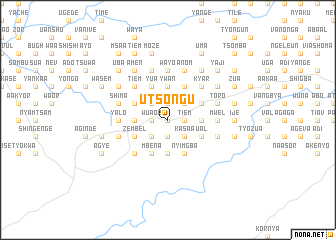
Utsongu (Gongola, Nigeria)Utsongu is a town in the Gongola region of Nigeria. An overview map of the region around Utsongu is displayed below.
regional and 3d topo map of Utsongu, Nigeria ::
Utsongu airports ::
The nearest airport is MDI - Makurdi, located 78.0 km north of Utsongu.
Other airports nearby include ENU - Enugu (153.5 km south west), BPC - Bamenda (180.1 km south east), BFX - Bafoussam (236.1 km south east), FOM - Foumban Nkounja (262.4 km south east), Nearby towns ::
Dekuku (0.0km north) //
Aken (0.0km north) //
Iornyagh (0.0km north) //
Sina (0.0km north) //
Kamzende (0.0km north) //
Agbaki (0.0km north) //
Iorlaha (1.8km west) //
Ortese (1.8km west) //
Chea (1.8km west) //
Iortiel (1.8km west) //
Ali (1.8km west) //
Agbeede (1.8km west) //
Wuaor (1.8km west) //
Amolor (1.8km west) //
Sado (1.9km south) //
Zwabo (1.9km south) //
Anjo (1.9km south) //
Tswaka (1.9km south) //
Kor (1.9km south) //
Timve (1.9km south) //
Akul (1.9km south) //
Amoior (1.9km south) //
Shuul (1.9km south) //
Shamange (1.8km east) //
Akile (1.8km east) //
Akpughul (1.8km east) //
Aule (1.9km north) //
Ibila (1.8km east) //
Akighil (1.9km north) //
[all distances 'as the bird flies' and approximate] 
Disclaimer :: Information on this page comes without warranty of any kind |
||
|
Where is Utsongu? Elevation and coordinates ::
Latitude (lat): 7°2'0"N Longitude (lon): 8°50'0"E
Elevation (approx.): 163m (map arrows pan, magnifying glasses zoom) |
||
|
Visiting Utsongu? Hotel/Accommodation ::
Book a hotel in Utsongu Travel Guide ::
Buy a travel guide for Nigeria rental cars ::
car rental offers GPS waypoint ::
download a GPX waypoint (PoI) of Utsongu for your GPS receiver
|
||