|
search place name
|
||
Kongja-dong (Hamgyŏng, Korea, North)Kongja-dong is a town in the Hamgyŏng region of Korea, North. An overview map of the region around Kongja-dong is displayed below.
regional and 3d topo map of Kongja-dong, Korea, North ::

Kongja-dong airports ::
The nearest airport is VVO - Vladivostok Knevichi, located 179.1 km north east of Kongja-dong.
Nearby towns ::
Tongnim-ni (1.4km east) //
Yusu-dong (1.8km south) //
Anwŏl-li (2.1km north east) //
Sedong-ni (3.0km north west) //
Ch'ŏnggye-dong (3.7km south) //
Tongnim-ni (3.3km east) //
Yongbung-nodongjagu (4.4km south east) //
Wŏllo-dong (4.0km west) //
Kogŏnwŏl-lodongjagu (4.7km south east) //
Nae-dong (5.7km north) //
Nongp'o-ri (5.8km north) //
Kŭmdong-ni (6.4km north) //
Yonghyŏl-li (6.9km south) //
I-dong (6.4km north east) //
Yŏngdang-ni (5.5km north east) //
Nongp'o-ri (6.8km north east) //
Kogŏn-dong (7.5km south) //
Nadan-dong (6.9km south west) //
Sŏkhyŏn-dong (8.8km north) //
Hamahyŏn-dong (8.5km south east) //
Yangdong-ni (9.2km north) //
Yongnam-ni (9.1km south east) //
[all distances 'as the bird flies' and approximate] 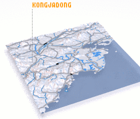 Places with similar names to Kongja-dong, Korea, North ::
// Kangje-dong (KP)
// Kangji-dong (KP)
// Kongja-dong (KP)
// Kangjitang (CN)
// Gongjiatang (CN)
// Gongjitang (CN)
Disclaimer :: Information on this page comes without warranty of any kind |
||
|
Where is Kongja-dong? Elevation and coordinates ::
Latitude (lat): 42°42'0"N Longitude (lon): 130°10'0"E
Elevation (approx.): 118m (map arrows pan, magnifying glasses zoom) |
||
|
Visiting Kongja-dong? Hotel/Accommodation ::
Book a hotel in Kongja-dong Travel Guide ::
rental cars ::
car rental offers GPS waypoint ::
download a GPX waypoint (PoI) of Kongja-dong for your GPS receiver
|
||