|
search place name
|
||
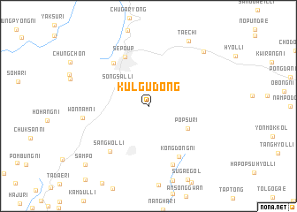
Kulgu-dong (Kangwŏn, Korea, North)Kulgu-dong is a town in the Kangwŏn region of Korea, North. An overview map of the region around Kulgu-dong is displayed below.
regional and 3d topo map of Kulgu-dong, Korea, North ::
Kulgu-dong airports ::
The nearest airport is SHO - Sokch'o Sokcho, located 116.5 km south east of Kulgu-dong.
Other airports nearby include GMP - Seoul Gimpo (125.3 km south west), SSN - Seoul East Seoul Ab (128.6 km south), KAG - Kangnung Gangneung (164.5 km south east), FNJ - Pyongyang Intl (165.1 km north west), Nearby towns ::
Paekpong (2.2km north) //
Kalmulp'o (4.0km north west) //
Sŏngsal-li (3.9km north west) //
Pŏpsu-ri (4.9km south east) //
Sep'o-ŭp (6.6km north) //
Sinsaeng-ni (6.4km north west) //
Kongdong-ni (7.1km south east) //
Sangwŏl-li (6.9km south west) //
Chŏmdae-gol (7.8km south) //
Wŏnnam-ni (6.6km west) //
Taech'i (9.1km north east) //
Sinp'yŏng-ni (8.8km north east) //
Samp'o (9.7km south west) //
[all distances 'as the bird flies' and approximate] 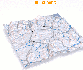 Places with similar names to Kulgu-dong, Korea, North ::
// Klokotnica (BA)
// Kalaktang (IN)
// Kalokitting (SD)
// Kalgae-dong (KP)
// Hkalu-gahtawng (MM)
// Kalauktaung (MM)
Disclaimer :: Information on this page comes without warranty of any kind |
||
|
Where is Kulgu-dong? Elevation and coordinates ::
Latitude (lat): 38°35'1"N Longitude (lon): 127°23'19"E
Elevation (approx.): 650m (map arrows pan, magnifying glasses zoom) |
||
|
Visiting Kulgu-dong? Hotel/Accommodation ::
Book a hotel in Kulgu-dong Travel Guide ::
rental cars ::
car rental offers GPS waypoint ::
download a GPX waypoint (PoI) of Kulgu-dong for your GPS receiver
|
||