|
search place name
|
||
Muang Mok (Xiangkhoang, Laos)Muang Mok is a town in the Xiangkhoang region of Laos. An overview map of the region around Muang Mok is displayed below.
regional and 3d topo map of Muang Mok, Laos ::

Muang Mok airports ::
The nearest airport is VTE - Vientiane Wattay Intl, located 184.7 km south west of Muang Mok.
Other airports nearby include SNO - Sakon Nakhon (190.8 km south), UTH - Udon Thani (213.5 km south west), LPQ - Luang Prabang Luang Phabang Intl (223.1 km north west), Nearby towns ::
Xieng Le (1.8km west) //
Phou Houm (5.1km north west) //
Nam Say (8.2km north west) //
Say He (8.2km north west) //
Ban Nam Mong (7.9km north west) //
[all distances 'as the bird flies' and approximate] 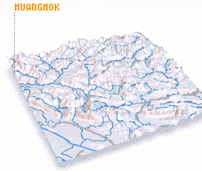 Places with similar names to Muang Mok, Laos ::
// Mān Kūmka (MM)
// Mān Kūmkai (MM)
// Mangamuka (NZ)
// Mangomuca (MZ)
// Mang May (2) (VN)
// Mangômuca (GW)
Disclaimer :: Information on this page comes without warranty of any kind |
||
|
Where is Muang Mok? Elevation and coordinates ::
Latitude (lat): 18°55'0"N Longitude (lon): 104°1'0"E
Elevation (approx.): 1110m (map arrows pan, magnifying glasses zoom) |
||
|
Visiting Muang Mok? Hotel/Accommodation ::
Book a hotel in Muang Mok Travel Guide ::
Buy a travel guide for Laos rental cars ::
car rental offers GPS waypoint ::
download a GPX waypoint (PoI) of Muang Mok for your GPS receiver
|
||