|
search place name
|
||
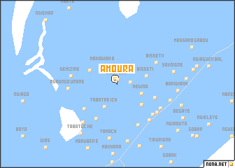
Amoura (Saint-Louis, Senegal)Amoura is a town in the Saint-Louis region of Senegal. An overview map of the region around Amoura is displayed below.
regional and 3d topo map of Amoura, Senegal ::
Amoura airports ::
The nearest airport is XLS - St. Louis Saint Louis, located 18.8 km south west of Amoura.
Other airports nearby include DKR - Dakar Leopold Sedar Senghor Intl (201.0 km south west), NKC - Nouakschott Nouakchott (215.6 km north), Nearby towns ::
Dios Peul (0.7km north) //
Treich Peul (2.0km east) //
Maka Diama (3.6km north west) //
Taba Treich (4.1km south west) //
Médina (4.0km east) //
Bissét I (4.6km east) //
Diama (4.8km north west) //
Mbeurbof (4.9km south east) //
Savoigne-Pionnier (6.1km east) //
Mbéraye (6.5km south west) //
Taba Darou Salam I (6.5km south west) //
Bissét II (6.8km north east) //
Ndialam (7.2km south east) //
Ndiol Nar (7.3km south east) //
Demizine (7.2km west) //
Ndiol Peul (7.5km south east) //
Mboltogne (7.5km south east) //
Nbéla (7.7km south east) //
Ngad Ngourane (7.6km west) //
Taba Ahmétou (8.1km south west) //
Tamach (8.8km south) //
Ndellé Boye (8.5km east) //
Taba Tache (9.7km south west) //
[all distances 'as the bird flies' and approximate]  Places with similar names to Amoura, Senegal ::
Disclaimer :: Information on this page comes without warranty of any kind |
||
|
Where is Amoura? Elevation and coordinates ::
Latitude (lat): 16°11'28"N Longitude (lon): 16°21'50"W
Elevation (approx.): 5m (map arrows pan, magnifying glasses zoom) |
||
|
Visiting Amoura? Hotel/Accommodation ::
Book a hotel in Amoura Travel Guide ::
Buy a travel guide for Senegal rental cars ::
car rental offers GPS waypoint ::
download a GPX waypoint (PoI) of Amoura for your GPS receiver
|
||