|
search place name
|
||
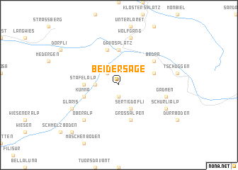
Bei der Säge (Aargau, Switzerland)Bei der Säge is a town in the Aargau region of Switzerland. An overview map of the region around Bei der Säge is displayed below.
regional and 3d topo map of Bei der Säge, Switzerland ::
Bei der Säge airports ::
The nearest airport is SMV - Samedan, located 26.1 km south of Bei der Säge.
Other airports nearby include ACH - St Gallen Altenrhein (82.5 km north), FDH - Friedrichshafen (103.5 km north), LUG - Lugano (110.5 km south west), BZO - Bolzano (119.3 km east), Nearby towns ::
Wity (1.9km south) //
Bolgen (2.2km north west) //
Clavadel (2.5km west) //
Sertig Döfli (3.9km south) //
Davos Platz (5.6km north) //
Davos Dorf (5.6km north) //
Stafel Alp (3.8km west) //
Schatzalp (5.7km north) //
Kriegsmatte (4.2km north east) //
Kumma (4.2km south west) //
Frauenkirch (4.2km south west) //
Grossalpen (5.7km south) //
Bedra (5.3km north east) //
Wolfgang (7.5km north) //
Gadmen (5.4km east) //
Oberalp (6.7km south west) //
Glaris (6.3km south west) //
Schürlialp (6.3km south east) //
Monstein (9.0km south west) //
[all distances 'as the bird flies' and approximate] 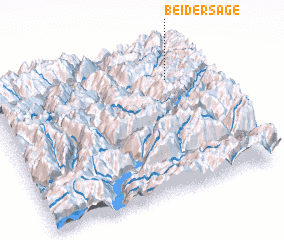 Places with similar names to Bei der Säge, Switzerland :: Disclaimer :: Information on this page comes without warranty of any kind |
||
|
Where is Bei der Säge? Elevation and coordinates ::
Latitude (lat): 46°46'0"N Longitude (lon): 9°50'0"E
Elevation (approx.): 2071m (map arrows pan, magnifying glasses zoom) |
||
|
Visiting Bei der Säge? Hotel/Accommodation ::
Book a hotel in Bei der Säge Travel Guide ::
Buy a travel guide for Switzerland rental cars ::
car rental offers GPS waypoint ::
download a GPX waypoint (PoI) of Bei der Säge for your GPS receiver
|
||