|
search place name
|
||
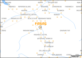
Finsing (Tirol, Austria)Finsing is a town in the Tirol region of Austria. An overview map of the region around Finsing is displayed below.
regional and 3d topo map of Finsing, Austria ::
Finsing airports ::
The nearest airport is INN - Innsbruck, located 40.4 km west of Finsing.
Other airports nearby include OBF - Oberpfaffenhofen (94.0 km north west), SZG - Salzburg (99.7 km north east), BZO - Bolzano (105.4 km south west), FEL - Fuerstenfeldbruck Furstenfeldbruck (106.9 km north west), Nearby towns ::
Haselbach (0.0km north) //
Helfenstein (0.0km north) //
Uderns (1.9km south) //
Kleinboden (1.3km west) //
Kapfing (1.3km west) //
Niederhart (1.9km north) //
Hart im Zillertal (2.2km north east) //
Fügen (2.2km north west) //
Ried im Zillertal (3.7km south) //
Grossried (3.7km south) //
Kleinried (3.7km south) //
Oberkaltenbach (3.7km south) //
Taxach (3.7km south) //
Holdernach (3.7km north) //
Gattererberg (3.9km south) //
Acham (3.9km south) //
Großmärz (3.9km south) //
Untermärz (3.9km south) //
Großhartberg (3.9km north) //
Fügenberg (3.1km north west) //
Gagering (3.9km north) //
Schlitters (4.5km north west) //
Kaltenbach (5.6km south) //
Emberg (5.7km south) //
Unterkaltenbach (5.7km south) //
Stumm (5.7km south) //
Pankrazberg (4.2km south west) //
Imming (5.7km north) //
Bruck am Ziller (5.7km north) //
[all distances 'as the bird flies' and approximate]  Places with similar names to Finsing, Austria ::
Disclaimer :: Information on this page comes without warranty of any kind |
||
|
Where is Finsing? Elevation and coordinates ::
Latitude (lat): 47°20'0"N Longitude (lon): 11°52'0"E
Elevation (approx.): 545m (map arrows pan, magnifying glasses zoom) |
||
|
Visiting Finsing? Hotel/Accommodation ::
Book a hotel in Finsing Travel Guide ::
Buy a travel guide for Austria rental cars ::
car rental offers GPS waypoint ::
download a GPX waypoint (PoI) of Finsing for your GPS receiver
|
||