|
search place name
|
||
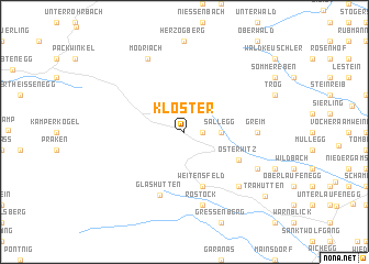
Kloster (Steiermark, Austria)Kloster is a town in the Steiermark region of Austria. An overview map of the region around Kloster is displayed below.
regional and 3d topo map of Kloster, Austria ::
nearby GPS traces from timatio ::
Kloster airports ::
The nearest airport is GRZ - Graz, located 29.7 km north east of Kloster.
Other airports nearby include KLU - Klagenfurt (Worthersee Intl) (62.9 km south west), MBX - Maribor (64.3 km south east), LJU - Ljubliana Ljubljana (87.6 km south west), ZAG - Zagreb (147.7 km south east), Nearby towns ::
Sankt Oswald im Freiland (1.3km east) //
Sallegg (2.5km east) //
Weitensfeld (5.7km south) //
Osterwitz (4.7km south east) //
Glashütten (6.6km south) //
Greim (5.1km east) //
Rostock (7.5km south) //
Freiland bei Deutschlandsberg (6.7km south east) //
Mitterspiel (6.3km south east) //
Modriach (7.8km north) //
Trahütten (8.6km south east) //
[all distances 'as the bird flies' and approximate]  Places with similar names to Kloster, Austria ::
Disclaimer :: Information on this page comes without warranty of any kind |
||
|
Where is Kloster? Elevation and coordinates ::
Latitude (lat): 46°53'0"N Longitude (lon): 15°5'0"E
Elevation (approx.): 904m (map arrows pan, magnifying glasses zoom) |
||
|
Visiting Kloster? Hotel/Accommodation ::
Book a hotel in Kloster Travel Guide ::
Buy a travel guide for Austria rental cars ::
car rental offers GPS waypoint ::
download a GPX waypoint (PoI) of Kloster for your GPS receiver
|
||