|
search place name
|
||
Palting (Austria)Palting is a town in Austria. An overview map of the region around Palting is displayed below.
regional and 3d topo map of Palting, Austria ::

Palting airports ::
The nearest airport is SZG - Salzburg, located 26.6 km south of Palting.
Other airports nearby include LNZ - Linz (Horsching) (82.1 km east), MUC - Munich Munchen (107.0 km west), OBF - Oberpfaffenhofen (138.1 km west), FEL - Fuerstenfeldbruck Furstenfeldbruck (140.6 km west), Nearby towns ::
Kerschham (1.9km north) //
Astätt (1.2km east) //
Babenham (2.2km north east) //
Mundenham (2.2km south west) //
Guggenberg (2.2km south west) //
Jeging (3.7km north) //
Kitzing (3.7km north) //
Weikertsham (2.5km west) //
Scherschham (2.5km east) //
Siegertshaft (3.9km north) //
Kirchberg bei Mattighofen (3.1km north west) //
Abern (3.9km north) //
Gebertsham (3.9km south) //
Auerbach (4.5km north west) //
Zellhof (4.5km south west) //
Pfaffstätt (5.6km north) //
Lochen (3.7km east) //
Valentinhaft (4.2km north east) //
Sauldorf (4.2km north west) //
Obernberg (5.7km south) //
Feldbach (4.2km south east) //
Perwang (4.2km south west) //
Wallsberg (5.7km south) //
Reitsham (5.7km south) //
Stemesedt (4.9km south west) //
Achenlohe (5.2km north east) //
Mattsee (6.1km south west) //
Gransdorf (5.3km south west) //
Fraham (5.3km south west) //
[all distances 'as the bird flies' and approximate] 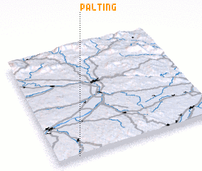 Places with similar names to Palting, Austria ::
// Palidaung (MM)
// Plitting (DE)
// Polding (DE)
// Polding (DE)
// Platanákia (GR)
// Platanákia (GR)
// Platanákia (GR)
// Platanákia (GR)
// Platanákia (GR)
// Płudnica (PL)
Disclaimer :: Information on this page comes without warranty of any kind |
||
|
Where is Palting? Elevation and coordinates ::
Latitude (lat): 48°1'0"N Longitude (lon): 13°8'0"E
Elevation (approx.): 526m (map arrows pan, magnifying glasses zoom) |
||
|
Visiting Palting? Hotel/Accommodation ::
Book a hotel in Palting Travel Guide ::
Buy a travel guide for Austria rental cars ::
car rental offers GPS waypoint ::
download a GPX waypoint (PoI) of Palting for your GPS receiver
|
||